Share to: share facebook share twitter share wa share telegram print page

Mount Horeb Earthworks Complex

Mount Horeb Earthworks Complex
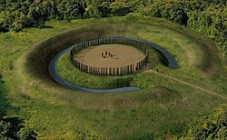
Artists conception of Mount Horeb Site 1
Mount Horeb Earthworks Complex is located in Kentucky
Mount Horeb Earthworks Complex
Location within Kentucky today
LocationLexington, KentuckyFayette County, Kentucky USA
RegionFayette County, Kentucky
Coordinates38°9′32″N 84°27′56″W / 38.15889°N 84.46556°W / 38.15889; -84.46556
History
CulturesAdena culture
Site notes
Excavation dates1939
ArchaeologistsWilliam S. Webb
Architecture
Architectural stylesEarthworks, causewayed ring ditch, timber circle

The Mount Horeb Earthworks Complex is an Adena culture group of earthworks in Lexington, Kentucky. It consists of two major components, the Mount Horeb Site 1 and the Peter Village enclosure, and several smaller features including the Grimes Village site, Tarleton Mound, and Fisher Mound.[1] The Peter Village and Grimes Village enclosures were mapped by Rafinesque and featured in Squier and Davis's landmark publication Ancient Monuments of the Mississippi Valley in 1848 as Plate XIV Figures 3 and 4.[2]

Mount Horeb Site 1

This site is the center piece of the University of Kentucky's Adena Park and is located on a bank 75 feet (23 m) above Elkhorn Creek. It features a causewayed ring ditch with a circular 105-foot (32 m) diameter platform, surrounded by a 45-foot (14 m) wide ditch and a 13-foot (4.0 m) wide enclosure with a 33-foot (10 m) wide entryway facing to the west. In 1939 the site was excavated by William S. Webb and the Works Projects Administration. They discovered the postholes of a circular wooden structure on the platform, which Webb speculated was a ceremonial center for a nearby clan.[1] The 48.5 feet (14.8 m) timber circle was made up of 132 posts, 62 "paired" posts and 8 single posts.[3] In 1936 the site and 6 acres (2.4 hectares) were paid for through private donations and transferred to the Kentucky Archaeological Society. It is currently owned and operated by the University of Kentucky as part of the Campus Recreation Department.[1]

Peter Village enclosure

The earliest occupation at this site is 300 to 200 BCE and is considered to be a pre-Adena site for harvesting and processing galena, which occurs naturally nearby. At this time the site had an earthen enclosure and a palisade and later a 2-meter (6.6 ft) deep ditch.[4] Rafinesque described the site as a twenty sided icosogonal polygon 3,767 feet (1,148 m) long with a 15 feet (4.6 m) wide 4 feet (1.2 m) to 8 feet (2.4 m) deep ditch surrounding it. An entryway to the enclosure was located to the south.[1]

Images in Squier and Davis

Mount Horeb, described as "ancient work near Lexington, Kentucky," was featured in the 1848 book Ancient Monuments of the Mississippi Valley by Ephraim George Squier and Edwin Hamilton Davis.[5]

See also

References

  1. ^ a b c d Susan L. Woodward; Jerry N. McDonald (2002). Indian Mounds of the Middle Ohio Valley. McDonald and Woodward Publishing. pp. 109–113. ISBN 0-939923-72-6.
  2. ^ E. G. Squier and E. H. Davis (1848). Ancient Monuments of the Mississippi Valley. Smithsonian Institution.
  3. ^ Sizemore, Judy (2008). "Mt Horeb : Adena People Teacher Companion Guide" (PDF). Kentucky Heritage Council.
  4. ^ Lewis, R. Barry (1996). Kentucky Archaeology. University Press of Kentucky. pp. 99–100. ISBN 0-8131-1907-3.
  5. ^ Ephraim George Squier; Edwin Hamilton Davis (1848). Ancient Monuments of the Mississippi Valley. Smithsonian Institution. p. 93.

Read other articles:

On the WayPoster teatrikalSutradara Kim Poog-ki ProduserDitulis olehPemeranWen Zhang Eva Huang Ji Jin-hee Cha Soo-yeonTanggal rilis 28 Maret 2014 (2014-03-28) (Tiongkok) Durasi94 menitNegara Tiongkok Korea Selatan Bahasa Tionghoa Korea PendapatankotorUS$3,220,000[1] On the Way (Bahasa Tionghoa: 我在路上最爱你) (Bahasa Korea: 길 위에서) adalah film drama-romansa Tiongkok-Korea Selatan tahun 2014 yang disutradarai oleh Kim Poog-ki dan dibintangi oleh Wen Zhang, Eva Huan…

У Вікіпедії є статті про інші значення цього терміна: Парк культури та відпочинку. Парк культури і відпочинку(Рахів) 48°03′ пн. ш. 24°11′ сх. д. / 48.050° пн. ш. 24.183° сх. д. / 48.050; 24.183Координати: 48°03′ пн. ш. 24°11′ сх. д. / 48.050° пн. ш…

South African born English cricketer (1946–2012) For the wrestler, see Tony Greig (wrestler). Tony GreigPersonal informationFull nameAnthony William GreigBorn(1946-10-06)6 October 1946Queenstown, Cape Province, South AfricaDied29 December 2012(2012-12-29) (aged 66)Sydney, New South Wales, AustraliaHeight6 ft 6 in (1.98 m)BattingRight-handedBowlingRight-arm mediumRight-arm off breakRoleAll-rounderRelationsIan Greig (brother)Norman Curry (brother-in-law)International inf…

1 Timotius 1Lembaran yang memuat 1 Timotius 2:2-6 pada Codex Coislinianus, yang dibuat sekitar tahun 550 M.KitabSurat 1 TimotiusKategoriSurat-surat PaulusBagian Alkitab KristenPerjanjian BaruUrutan dalamKitab Kristen15← 2 Tesalonika 3 pasal 2 → 1 Timotius 1 (disingkat 1Tim 1) adalah bagian pertama dari Surat Paulus yang Pertama kepada Timotius dalam Perjanjian Baru di Alkitab Kristen.[1][2] Digubah oleh rasul Paulus[3] dan ditujukan kepada Timotius.[4]…

This article does not cite any sources. Please help improve this article by adding citations to reliable sources. Unsourced material may be challenged and removed.Find sources: Most Known Hits – news · newspapers · books · scholar · JSTOR (December 2009) (Learn how and when to remove this template message) 2005 greatest hits album by Three 6 MafiaMost Known HitsGreatest hits album by Three 6 MafiaReleasedNovember 15, 2005Recorded1996–2005GenreSo…

РавільRaville   Країна  Франція Регіон Гранд-Ест  Департамент Мозель  Округ Мец Кантон Панж Код INSEE 57563 Поштові індекси 57530 Координати 49°05′38″ пн. ш. 6°29′11″ сх. д.H G O Висота 215 - 310 м.н.р.м. Площа 7,06 км² Населення 250 (01-2020[1]) Густота 37,25 ос./км² Розміщення Влада

Детмольднім. Detmold герб прапор Князівська замок.Князівська замок. Основні дані 51°56′16″ пн. ш. 8°53′00″ сх. д. / 51.93777777780577765° пн. ш. 8.88333333336107777711276867° сх. д. / 51.93777777780577765; 8.88333333336107777711276867Координати: 51°56′16″ пн. ш. 8°53′00″ сх. д. / 51.9377…

Расінг — термін, який має кілька значень. Ця сторінка значень містить посилання на статті про кожне з них.Якщо ви потрапили сюди за внутрішнім посиланням, будь ласка, поверніться та виправте його так, щоб воно вказувало безпосередньо на потрібну статтю.@ пошук посилань сам

Peruvian singer You can help expand this article with text translated from the corresponding article in Spanish. (September 2014) Click [show] for important translation instructions. Machine translation, like DeepL or Google Translate, is a useful starting point for translations, but translators must revise errors as necessary and confirm that the translation is accurate, rather than simply copy-pasting machine-translated text into the English Wikipedia. Consider adding a topic to this temp…

Tangalle FortPart of Hambantota DistrictTangalle, Sri Lanka Tangalle FortCoordinates6°1′21″N 80°47′53″E / 6.02250°N 80.79806°E / 6.02250; 80.79806TypeDefence fortHeight12 m (39 ft)Site informationControlled byGovernment of Sri LankaOpen tothe publicnoConditiongoodSite historyBuilt byDutchMaterialslimestone and coral Tangalle Fort (Sinhala: තංගල්ල බලකොටුව, romanized: Tangalla Balakotuwa; Tamil: தங…

п о р УніверсіадиЛітні 1959 • 1961 • 1963 • 1965 • 1967 • 1970 • 1973 • 1975 • 1977 • 1979 • 1981 • 1983 • 1985 • 1987 • 1989 • 1991 • 1993 • 1995 • 1997 • 1999 • 2001 • 2003 • 2005 • 2007 • 2009 • 2011 • 2013 • 2015 • 2017 • 2019 • 2023 • 2025 • 2027 Зимові 1960 • 1962 • 1964 • 1966 • 1968 • 1970 • 1972 • 1975 • 1978 • 1981 • 1983 • 1985 • 1987 • 1989 • 1991 • 1993 • 1995 •…

No debe confundirse con estación de Villaverde Alto. Para la estación del Metro de Madrid, véase estación de Villaverde Bajo-Cruce. Villaverde Bajo Vista de la estación en 2016.UbicaciónCoordenadas 40°21′09″N 3°41′02″O / 40.3526, -3.68401Dirección Gran Vía de VillaverdeDistrito VillaverdeMunicipio MadridZona Datos de la estaciónCódigo 60100Inauguración 1851N.º de andenes 3N.º de vías 6Propietario AdifOperador RenfeTráfico actual Ver salidas y llegadasServ…

Der Titel dieses Artikels ist mehrdeutig. Weitere Bedeutungen sind unter Pötting (Begriffsklärung) aufgeführt. Pötting Wappen Österreichkarte Pötting (Österreich) Basisdaten Staat: Österreich Bundesland: Oberösterreich Politischer Bezirk: Grieskirchen Kfz-Kennzeichen: GR Fläche: 7,43 km² Koordinaten: 48° 17′ N, 13° 46′ O48.28333333333313.774166666667381Koordinaten: 48° 17′ 0″ N, 13° 46′ 27″ O Höhe: 381 m …

United States military facility located in Prince George's County, Maryland Joint Base AndrewsCamp Springs, Maryland in the United States of AmericaBoeing VC-25A, widely known as Air Force One when the President is on board, of the 89th Airlift Wing based at JB Andrews.Motto: America's AirfieldJB AndrewsLocation in the United StatesCoordinates38°48′39″N 076°52′01″W / 38.81083°N 76.86694°W / 38.81083; -76.86694 (Andrews Field)TypeUS military Joint …

Political campaign to strengthen the U.S. military after the outbreak of World War I This article is about the state of the U.S. military prior to entry in World War I. For disaster preparedness, see Survivalism. The Preparedness Movement was a campaign led by former Chief of Staff of the U.S. Army, Leonard Wood, and former President Theodore Roosevelt to strengthen the U.S. military after the outbreak of World War I.[1][2][3] Wood advocated a summer training school for r…

British egyptologist Barbara G. AdamsAdams c. 1980Born19 February 1945London, EnglandDied26 June 2002(2002-06-26) (aged 57)London Borough of Enfield, EnglandNationalityEnglishOccupationEgyptologist Barbara Georgina Adams, FRSA (19 February 1945 – 26 June 2002) was a distinguished British Egyptologist, archaeologist, and academic, who was a specialist in Prehistoric Egypt. She worked for many years at Hierakonpolis, where she was the co-director of the expedition. She worked at the Pet…

Comic book series by DC Comics This article needs additional citations for verification. Please help improve this article by adding citations to reliable sources. Unsourced material may be challenged and removed.Find sources: The Batman Chronicles – news · newspapers · books · scholar · JSTOR (September 2017) (Learn how and when to remove this template message) The Batman ChroniclesCover of The Batman Chronicles #1 (May 1995), art by Bill Sienkiewicz and …

Der SC Hakoah Wien (hebräisch הַכֹּחַ וִינָה ha-Koach Winah, deutsch ‚die Kraft Wien‘) ist ein jüdischer Sportverein in Wien, der ursprünglich zur „Pflege des Fussballspieles, der Leicht- und Schwer-Athletik, des Winter- und Wasser-Sportes“ gegründet wurde.[1] Beheimatet ist der 1909 gegründete SC Hakoah Wien in der Wiener Krieau. Nach dem Anschluss Österreichs 1938 zerschlugen die Nationalsozialisten den Verein, dessen Mitglieder sie verfolgten. Nach E…

2023 novel by Jessica George Maame AuthorJessica GeorgeLanguageEnglishGenreFictionPublished2023PublisherSt. Martin's Press Maame is a 2023 literary fiction novel written by Jessica George. George's debut novel, was published in 2023 by St. Martin's Press.[1][2][3] The novel was named the February 2023 book club pick on The Today Show.[4][5] Plot Maddie, a young woman in London, struggles to balance her life as caretaker of her critically ill father, her mo…

Peta infrastruktur dan tata guna lahan di Komune Douy-la-Ramée.  = Kawasan perkotaan  = Lahan subur  = Padang rumput  = Lahan pertanaman campuran  = Hutan  = Vegetasi perdu  = Lahan basah  = Anak sungaiDouy-la-RaméeNegaraPrancisArondisemenMeauxKantonLizy-sur-OurcqAntarkomuneCommunauté de communes du Pays de l'OurcqPemerintahan • Wali kota (2008-2014) Nadine Caron • Populasi1234Kode INSEE/pos77163 / 2 Population sans doubles …

Kembali kehalaman sebelumnya

Lokasi Pengunjung: 13.58.74.131