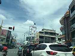
Tebing Tinggi
Tebing Tinggi Deli, officially Tebing Tinggi City, or more commonly simply Tebing Tinggi (Jawi: تبيڠ تيڠڬي) is a city near the eastern coast of North Sumatra Province of Indonesia. It has an area of 38.44 km2 and a population at the 2010 Census of 145,180,[2] which grew to 172,838 at the 2020 Census;[3] the official estimate as at mid 2024 was 180,977 (comprising 90,018 males and 90,959 females).[1] Tebing Tinggi is an enclave within Serdang Bedagai Regency (which surrounds it on all sides, and also contains a kecamatan (district) bordering the city that is also named Tebing Tinggi). GeographyAccording to the Agency for Information and Communication Data North Sumatra, Tebing Tinggi is one of the 8 independent cities (formerly called municipalities) in North Sumatra, located around 80 km from Medan (the capital of North Sumatra Province) and situated at a crossroads of the Trans-Sumatran Highway, connecting the East Coast Highway; Tanjungbalai, Rantau Prapat, and Central Sumatra Highway; Pematangsiantar, Parapat, and Balige. Administrative districtsThe city is divided administratively into five districts, tabulated below with their areas and their populations at the 2010 Census[2] and the 2020 Census,[3] together with the official estimates as at mid 2024.[1] The table also includes the number of administrative villages in each district (all classed as urban kelurahan), and its post code.
DemographicsThe residents of Tebing Tinggi are Malays (70%), Batak (11%), and Chinese (8%). Javanese, Mandailing, Indian, and other ethnicities are recognized ethnic minorities. The city's religion is predominantly Islam, followed by Christianity, Buddhism, and other religions. ClimateTebing Tinggi has a tropical rainforest climate (Af) with heavy rainfall year-round.
ReferencesExternal linksWikimedia Commons has media related to Tebing Tinggi (North Sumatra).
|
||||||||||||||||||||||||||||||||||||||||||||||||||||||||||||||||||||||||||||||||||||||||||||||||||||||||||||||||||||||||||||||||||||||||||||||||||||||||||||||||||||||||||||||||||||||||||||||||||||||||||||||||


