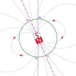
Geomagnetic pole

Illustration of the difference between geomagnetic poles (Nm and Sm) and geographical poles (Ng and Sg)
Location of the north magnetic pole and the north geomagnetic pole in 2017.[1]

The geomagnetic poles are antipodal points where the axis of a best-fitting dipole intersects the surface of Earth. This theoretical dipole is equivalent to a powerful bar magnet at the center of Earth, and comes closer than any other point dipole model to describing the magnetic field observed at Earth's surface. In contrast, the magnetic poles of the actual Earth are not antipodal; that is, the line on which they lie does not pass through Earth's center.

Owing to the motion of fluid in the Earth's outer core, the actual magnetic poles are constantly moving (secular variation). However, over thousands of years, their direction averages to the Earth's rotation axis. On the order of once every half a million years, the poles reverse (i.e., north switches place with south) although the time frame of this switching can be anywhere from every 10 thousand years to every 50 million years.[2] The poles also swing in an oval of around 50 miles (80 km) in diameter daily due to solar wind deflecting the magnetic field.[3]

Although the geomagnetic pole is only theoretical and cannot be located directly, it arguably is of more practical relevance than the magnetic (dip) pole. This is because the poles describe a great deal about the Earth's magnetic field, determining for example where auroras can be observed. The dipole model of the Earth's magnetic field consists of the location of geomagnetic poles and the dipole moment, which describes the strength of the field.[3]

Recent locations of Earth's geomagnetic (auroral) poles, IGRF-13 fit[4]
Year 1990 (definitive) 2000 (definitive) 2010 (definitive) 2020
North geomagnetic pole 79°12′N 71°06′W / 79.2°N 71.1°W / 79.2; -71.1 (NGMP 1990) 79°36′N 71°36′W / 79.6°N 71.6°W / 79.6; -71.6 (NGMP 2010) 80°06′N 72°12′W / 80.1°N 72.2°W / 80.1; -72.2 (NGMP 2020) 80°42′N 72°42′W / 80.7°N 72.7°W / 80.7; -72.7 (NGMP 2020)
South geomagnetic pole 79°12′S 108°54′E / 79.2°S 108.9°E / -79.2; 108.9 (SGMP 1990) 79°36′S 108°24′E / 79.6°S 108.4°E / -79.6; 108.4 (SGMP 2000) 80°06′S 107°48′E / 80.1°S 107.8°E / -80.1; 107.8 (SGMP 2010) 80°42′S 107°18′E / 80.7°S 107.3°E / -80.7; 107.3 (SGMP 2020)
Magnetic dipole moment (1022 A ⋅ m2) 7.84 7.79 7.75 7.71

Definition

As a first-order approximation, the Earth's magnetic field can be modeled as a simple dipole (like a bar magnet), tilted about 9.6° with respect to the Earth's rotation axis (which defines the Geographic North and Geographic South Poles) and centered at the Earth's center.[5] The North and South Geomagnetic Poles are the antipodal points where the axis of this theoretical dipole intersects the Earth's surface. Thus, unlike the actual magnetic poles, the geomagnetic poles always have an equal degree of latitude and supplementary degrees of longitude respectively (2017: Lat. 80.5°N, 80.5°S; Long. 72.8°W, 107.2°E).[4] If the Earth's magnetic field were a perfect dipole, the field lines would be vertical to the surface at the Geomagnetic Poles, and they would align with the North and South magnetic poles, with the North Magnetic Pole at the south end of dipole. However, the approximation is imperfect, and so the Magnetic and Geomagnetic Poles lie some distance apart.[6]

Location

Like the North Magnetic Pole, the North Geomagnetic Pole attracts the north pole of a bar magnet and so is in a physical sense actually a magnetic south pole. It is the center of the 'open' magnetic field lines which connect to the interplanetary magnetic field and provide a direct route for the solar wind to reach the ionosphere. As of 2020, it was located at 80°39′N 72°41′W / 80.65°N 72.68°W / 80.65; -72.68 (Geomagnetic North Pole 2020 est),[7] on Ellesmere Island, Nunavut, Canada, compared to 2015, when it was located at 80°22′N 72°37′W / 80.37°N 72.62°W / 80.37; -72.62 (Geomagnetic North Pole 2015 est), also on Ellesmere Island.[5]

The South Geomagnetic Pole is the point where the axis of this best-fitting tilted dipole intersects the Earth's surface in the southern hemisphere. As of 2020, it is located at 80°39′S 107°19′E / 80.65°S 107.32°E / -80.65; 107.32 (Geomagnetic South Pole 2020 est),[7] whereas in 2005, it was calculated to be located at 79°44′S 108°13′E / 79.74°S 108.22°E / -79.74; 108.22 (Geomagnetic South Pole 2005 est), near Vostok Station.

Because the Earth's actual magnetic field is not an exact dipole, the (calculated) North and South Geomagnetic Poles do not coincide with the North and South Magnetic Poles. If the Earth's magnetic fields were exactly dipolar, the north pole of a magnetic compass needle would point directly at the North Geomagnetic Pole. In practice, it does not because the geomagnetic field that originates in the core has a more complex non-dipolar part, and magnetic anomalies in the Earth's crust also contribute to the local field.[5]

The locations of geomagnetic poles are calculated by a statistical fit to measurements of the Earth's field by satellites and in geomagnetic observatories. This can be the International Geomagnetic Reference Field (covering a wide time-span in history)[8] or the U.S. World Magnetic Model (only covering a five-year period).

Movement

The geomagnetic poles move over time because the geomagnetic field is produced by motion of the molten iron alloys in the Earth's outer core. (See geodynamo.) Over the past 150 years, the poles have moved westward at a rate of 0.05° to 0.1° per year and closer to the true poles at 0.01° per year.[6]

Over several thousand years, the average location of the geomagnetic poles coincides with the geographical poles. Paleomagnetists have long relied on the geocentric axial dipole (GAD) hypothesis, which states that — aside from during geomagnetic reversals — the time-averaged position of the geomagnetic poles has always coincided with the geographic poles. There is considerable paleomagnetic evidence supporting this hypothesis.[9]

Geomagnetic reversal

Over the life of the Earth, the orientation of Earth's magnetic field has reversed many times, with geomagnetic north becoming geomagnetic south and vice versa – an event known as a geomagnetic reversal. Evidence of geomagnetic reversals can be seen at mid-ocean ridges where tectonic plates move apart. As magma seeps out of the mantle and solidifies to become new ocean floor, the magnetic minerals in it are magnetized in the direction of the magnetic field. The study of this remanence is called palaeomagnetism. Thus, starting at the most recently formed ocean floor, one can read out the direction of the magnetic field in previous times as one moves farther away to older ocean floor.

See also

Notes

  1. ^ "Magnetic North, Geomagnetic and Magnetic Poles". wdc.kugi.kyoto-u.ac.jp. Retrieved 2019-12-18.
  2. ^ "Is it true that Earth's magnetic field occasionally reverses its polarity?". www.usgs.gov. Retrieved 2021-09-16.
  3. ^ a b Nair, Manoj C. (10 March 2022). "Wandering of the Geomagnetic Poles | NCEI". www.ngdc.noaa.gov.
  4. ^ a b "Magnetic North: Geomagnetic and Magnetic Poles". World Data Center for Geomagnetism. Kyoto, Japan: Kyoto University. Retrieved 11 June 2018.
  5. ^ a b c "Geomagnetism Frequently Asked Questions". National Geophysical Data Center. Retrieved 1 June 2016.
  6. ^ a b Merrill, McElhinny & McFadden 1996, Chapter 2
  7. ^ a b "World Magnetic Model - Model Limitations". www.ngdc.noaa.gov. Retrieved 2020-01-17.
  8. ^ IAGA Division V Working Group V-MOD. "International Geomagnetic Reference Field". Retrieved 20 December 2016.
  9. ^ Merrill, McElhinny & McFadden 1996, Chapter 6

References

Read other articles:

Galaxie de BarnardNGC 6822 Vue de la galaxie de Barnard depuis l'ESO[1] Données d’observation(Époque J2000.0) Constellation Sagittaire[2] Ascension droite (α) 19h 44m 57,74s[3] Déclinaison (δ) −14° 48′ 12,4″ [3] Magnitude apparente (V) 8,1 [4] 9,3 dans la Bande B[4] Brillance de surface 14,55 mag/am2[4] Dimensions apparentes (V) 14,4′ × 15,4′[4] Décalage vers le rouge -0,000183 ± 0,000007[3] Angle de position 5°[4] Localisation dans la c...


Lambang Negara Armenia - Bahasa Armenia: Հայաստանի ԶինանշանDetailPemangkuRepublik ArmeniaDigunakan sejak19 April 1992PerisaiSebuah perisai dengan 4 lambang wangsa Armenia Artaxia, Arshakunian, Bagratuni, dan Rubinian; Di tengah menampilkan Gunung Ararat dengan Bahtera Nuh di atasnyaPenopangSeekor Elang dan SingaKompartemenHimpunan bunga gandum, bulu burung, rantai terputus, pita, dan pedang[1]Versi awal1918-1920, Republik Demokratik ArmeniaPenggunaanpada mata uang; di...


Part of a series on theCulture of Rwanda History History of Rwanda Timeline Origins of Hutu, Tutsi and Twa Kingdom of Rwanda kings German East Africa Ruanda-Urundi Colonial residents Ruzagayura famine Rwandan Revolution Bugesera invasion Rwandan Civil War Rwandan genocide Initial events Second Congo War People Languages Cuisine Religion Art Literature Music Media Radio Television Cinema Sport Monuments World Heritage Sites Symbols Flag Coat of arms National anthem vte The largest ethnic grou...

Village in Powys, Wales Human settlement in WalesCwmdauddwrLocation within PowysCommunityRhayaderPrincipal areaPowysPreserved countyPowysCountryWalesSovereign stateUnited KingdomPoliceDyfed-PowysFireMid and West WalesAmbulanceWelsh List of places UK Wales Powys 52°17′54″N 3°31′00″W / 52.2984°N 3.5167°W / 52.2984; -3.5167 Cwmdauddwr (rarely referred to by its correct full name of Llansanffraid Cwmteuddwr[1]) is a village in Powys, Wale...


Head of the Indian Ministry of Education This article has multiple issues. Please help improve it or discuss these issues on the talk page. (Learn how and when to remove these template messages) This article needs additional citations for verification. Please help improve this article by adding citations to reliable sources. Unsourced material may be challenged and removed.Find sources: Minister of Education India – news · newspapers · books · scholar&#...


ХристианствоБиблия Ветхий Завет Новый Завет Евангелие Десять заповедей Нагорная проповедь Апокрифы Бог, Троица Бог Отец Иисус Христос Святой Дух История христианства Апостолы Хронология христианства Раннее христианство Гностическое христианство Вселенские соборы Н...

この記事は検証可能な参考文献や出典が全く示されていないか、不十分です。出典を追加して記事の信頼性向上にご協力ください。(このテンプレートの使い方)出典検索?: コルク – ニュース · 書籍 · スカラー · CiNii · J-STAGE · NDL · dlib.jp · ジャパンサーチ · TWL(2017年4月) コルクを打ち抜いて作った瓶の栓 コルク(木栓、�...


Category 5 Atlantic hurricane in 2017 This article is about the Atlantic hurricane of 2017. For other storms of the same name, see List of storms named Maria. Hurricane Maria Maria near peak intensity while southeast of the U.S. Virgin Islands late on September 19Meteorological historyFormedSeptember 16, 2017ExtratropicalSeptember 30, 2017DissipatedOctober 2, 2017Category 5 major hurricane1-minute sustained (SSHWS/NWS)Highest winds175 mph (280 km/h)Lowest pressure908 mbar ...


Chris Bauer al San Diego Comic-Con International 2014 Mark Christopher Bauer, noto come Chris Bauer (Los Angeles, 28 ottobre 1966), è un attore statunitense di origini tedesche e irlandesi, che lavora in campo cinematografico e televisivo. Indice 1 Biografia 2 Filmografia parziale 2.1 Cinema 2.2 Televisione 3 Doppiatori italiani 4 Altri progetti 5 Collegamenti esterni Biografia Nato in California, si diploma alla Miramonte High School a Orinda, California, nel 1984. Studia all'American Acade...

11th Master Chief Petty Officer of the Navy This biography of a living person needs additional citations for verification. Please help by adding reliable sources. Contentious material about living persons that is unsourced or poorly sourced must be removed immediately from the article and its talk page, especially if potentially libelous.Find sources: Joe Campa – news · newspapers · books · scholar · JSTOR (September 2011) (Learn how and when to remove...


Shane Duffy Duffy bermain untuk Brighton & Hove Albion pada 2018Informasi pribadiNama lengkap Shane Patrick Michael Duffy[1]Tanggal lahir 1 Januari 1992 (umur 32)[2]Tempat lahir Derry, Irlandia UtaraTinggi 1,93 m (6 ft 4 in)[2]Posisi bermain BekInformasi klubKlub saat ini Norwich CityNomor 24Karier junior Foyle Harps2008–2009 Everton[3]Karier senior*Tahun Tim Tampil (Gol)2009–2014 Everton 5 (0)2011 → Burnley (pinjaman) 1 (0)2011 �...


Canadian trophy for national senior amateur men's ice hockey champions Not to be confused with Allan Cup Hockey or Allan Cup Hockey West. Allan CupCurrent season, competition or edition: 2024 Allan CupSportIce hockeyFirst season1909Most recentchampion(s)Dundas Real McCoys (2023)Most titlesPort Arthur Bearcats/Thunder Bay Twins (9)TV partner(s)TSNOfficial websiteHockeyCanada.ca The Allan Cup is the trophy awarded annually to the senior ice hockey champions of Canada. It was donated by Sir Mont...

Jupiter as seen by the Juno spacecraft (2016) The collision of comet 9P/Tempel and the Deep Impact probe (2005) Since 1958, NASA has overseen more than 1,000 uncrewed missions into Earth orbit or beyond.[1] It has both launched its own missions and provided funding for private-sector missions. A number of NASA missions, including the Explorers Program, Voyager program, and New Frontiers program, are ongoing. List of missions Explorers Program (1958–present) Explorer 1 satellite. Ma...


State park in Suffolk County, New York Napeague State ParkNapeague State Park, May 2023Location of Napeague State Park within New York StateTypeState park (undeveloped)LocationTown of East HamptonSuffolk County, New YorkCoordinates40°59′23″N 72°04′37″W / 40.9897°N 72.0769°W / 40.9897; -72.0769Area1,364 acres (5.52 km2)[1]Operated byNew York State Office of Parks, Recreation and Historic PreservationVisitors65,985 (in 2014)[2&#...


لي بوم يونغ   معلومات شخصية الميلاد 2 أبريل 1989 (العمر 35 سنة)سول  الطول 1.95 م (6 قدم 5 بوصة) مركز اللعب حارس مرمى الجنسية كوريا الجنوبية  معلومات النادي النادي الحالي سوون المسيرة الاحترافية1 سنوات فريق م. (هـ.) 2008–2015 بوسان أي بارك 134 (0) 2016 أفيسبا فوكوكا 25 (0) 2017–2018 غا...

Island municipality in Greece Municipality in GreeceSifnos ΣίφνοςMunicipalityVillages of Apollonia and Katavathi seen from Ano PetaliSifnosLocation within the region Coordinates: 36°59′21″N 24°40′7″E / 36.98917°N 24.66861°E / 36.98917; 24.66861CountryGreeceAdministrative regionSouth AegeanRegional unitMilosGovernment • MayorMaria Nadali[1] (since 2019)Area • Municipality73.94 km2 (28.55 sq mi)Highest ...


Constituency of the Andhra Pradesh Legislative Assembly, India PalakondaConstituency No. 10 for the Andhra Pradesh Legislative AssemblyLocation of Palakonda Assembly constituency within Andhra PradeshConstituency detailsCountryIndiaRegionSouth IndiaStateAndhra PradeshDistrictParvathipuram ManyamLS constituencyArakuEstablished1951Total electors184,414ReservationSTMember of Legislative Assembly16th Andhra Pradesh Legislative AssemblyIncumbent Nimmaka Jayakrishna PartyJana Sena PartyElected year...


本條目存在以下問題,請協助改善本條目或在討論頁針對議題發表看法。 此条目序言章节没有充分总结全文内容要点。 (2023年6月8日)请考虑扩充序言,清晰概述条目所有重點。请在条目的讨论页讨论此问题。 此條目可参照英語維基百科相應條目来扩充。 (2023年6月8日)若您熟悉来源语言和主题,请协助参考外语维基百科扩充条目。请勿直接提交机械翻译,也不要翻译不可靠、...

Испания после реформы Цезаря Августа в 27 до н. э. Деление Испании на Ближнюю и Дальнюю в 197 до н. э.. Бли́жняя Испа́ния (лат. Hispania Citerior) — провинция Римской республики на Пиренейском полуострове, расположенная на северо-востоке современной Испании и в долине реки Эбро (�...


Portrait of Dr. GachetVersi ke-1SenimanVincent van GoghTahun1890MediumMinyak di kanvasUkuran67 cm × 56 cm (23.4 in × 22.0 in)LokasiKoleksi pribadi Potret Dr. GachetVersi ke-2SenimanVincent van GoghTahun1890MediumMinyak di kanvasUkuran67 cm × 56 cm (23.4 in × 22.0 in)LokasiMusée d'Orsay, Paris Potret Dr. Gachet adalah salah satu lukisan karya pelukis Belanda Vincent van Gogh. Lukisan tersebut menggambarkan...