Census-designated place in El Paso County, CO, USA
Census-designated place in Colorado, United States
Cimarron Hills, Colorado |
|---|
|
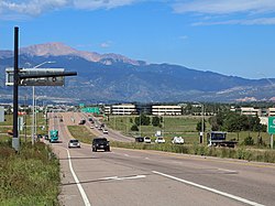 Looking west along East Platte Avenue in Cimarron Hills. |
 |
Location of the Cimarron Hills CDP, Colorado. Show map of the United StatesCimarron Hills (Colorado) Show map of Colorado |
| Coordinates: 38°51′31″N 104°41′56″W / 38.8586°N 104.6989°W / 38.8586; -104.6989 (Cimarron Hills, Colorado)[2] |
| Country | United States |
|---|
| State | Colorado |
|---|
| County | El Paso[1] |
|---|
|
| • Type | unincorporated community |
|---|
| • Body | El Paso County[1] |
|---|
|
• Total | 5.942 sq mi (15.391 km2) |
|---|
| • Land | 5.939 sq mi (15.382 km2) |
|---|
| • Water | 0.003 sq mi (0.009 km2) |
|---|
| Elevation | 6,447 ft (1,965 m) |
|---|
|
• Total | 19,311 |
|---|
| • Density | 3,200/sq mi (1,300/km2) |
|---|
| Time zone | UTC−07:00 (MST) |
|---|
| • Summer (DST) | UTC−06:00 (MDT) |
|---|
| ZIP code[5] | Colorado Springs 80914, 80915, and 80922 |
|---|
| Area code | 719 |
|---|
| GNIS place ID | 1867079 |
|---|
| GNIS CDP ID | 2407622 |
|---|
| FIPS code | 08-14587 |
|---|
Cimarron Hills is an unincorporated community and a census-designated place (CDP) located in and governed by El Paso County, Colorado, United States. Cimarron Hills is an enclave of the City of Colorado Springs. The CDP is a part of the Colorado Springs, CO Metropolitan Statistical Area. The population of the Cimarron Hills CDP was 19,311 at the United States Census 2020.[4]
Geography
The Cimarron Hills CDP has an area of 3,803 acres (15.391 km2), including 2.2 acres (0.009 km2) of water.[3]
Demographics
The United States Census Bureau initially defined the Cimarron Hills CDP for the 1980 United States census.
Transportation
Highway: Cimarron Hills is 1.5 miles north of U.S. Highway 24. It is also 9 miles from Interstate 25.
Air: The community is three miles north of the Colorado Springs Airport.
Rail: (Historical information) In 1888, the Chicago, Rock Island and Pacific Railroad began construction of a main line between Limon and Colorado Springs, passing through Cimarron Hills. The Rocky Mountain Rocket provided passenger service from 1939 to 1966. In later years, the Cadillac and Lake City Railroad provided service between Cimarron Hills and Limon. Although the tracks were removed in the 1980s, the railroad grade can still be seen as a prominent U-shape in aerial images of Cimarron Hills.
Education
The CDP is divided between School District 49 to the north (with most of the CDP) and the Colorado Springs School District 11 to the south.[6]
See also
References
- ^ a b "Colorado Counties". Colorado Department of Local Affairs. Retrieved July 9, 2025.
- ^ a b "Cimarron Hills, Colorado". Geographic Names Information System. United States Geological Survey, United States Department of the Interior. Retrieved July 9, 2025.
- ^ a b "State of Colorado Census Designated Places - BAS20 - Data as of January 1, 2020". United States Census Bureau. Retrieved December 21, 2020.
- ^ a b United States Census Bureau. "Cimarron Hills CDP, Colorado". Retrieved April 16, 2023.
- ^ "ZIP Code Lookup". United States Postal Service. Retrieved July 9, 2025.
- ^ Geography Division (December 17, 2020). 2020 CENSUS - SCHOOL DISTRICT REFERENCE MAP: El Paso County, CO (PDF) (Map). U.S. Census Bureau. Retrieved 2025-08-04. - Text list
External links


