Carrickmines

Carrickmines
Carraig Mhaighin
Suburb
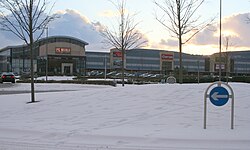
Carrickmines Retail Park
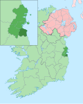
Carrickmines is located in Ireland
Carrickmines
Carrickmines
Location in Ireland
Coordinates: 53°14′53″N 6°10′52″W / 53.248°N 6.181°W / 53.248; -6.181
CountryIreland
ProvinceLeinster
CountyDublin
Elevation
130 m (430 ft)
Population
 (2006)
 • Urban
6,088
Eircode (Routing Key)
D18
Area code01 (+3531)
Irish Grid ReferenceO236249

Carrickmines (Irish: Carraig Mhaighin, meaning 'Plateau of rock') is an outer suburb of Dublin in Dún Laoghaire–Rathdown, Ireland. The area, still semi-rural, was historically on the border of English control and featured a defensive construction, Carrickmines Castle, which became the subject of national controversy during the building of a late stage of Dublin's M50 orbital motorway.

Character

Previously a rural area, and today a semi-rural suburban region, Carrickmines is now divided northeast–southwest by the M50 motorway, with, to the northeast, more established residential areas, and to the southwest, including along Glenamuck Road, new retail parks, office buildings, housing schemes and apartments.[citation needed]

Geography

Carrickmines developed as a settlement in the more than 6 km long valley of the same name, which contains the modest Carrickmines River and its tributaries. The Ballyogan, Glenamuck and Golf Streams all merge in the vicinity. Downstream at Brennanstown, the river merges with St. Bride's Stream, from Foxrock, to form the Loughlinstown River, which in turn meets the Bride's Glen Stream to form the Shanganagh River, which reaches the sea at Killiney Strand.[1]

Leopardstown lies to the northwest, Foxrock to the north, Cornelscourt and Cabinteely to the northeast and Brennanstown to the east, Ballyogan to the west, Glenamuck and Kilternan to the south, and Laughanstown and Lehaunstown to the southeast.[2][1]

The proposed Natural Heritage Area of 'Dingle Glen', a secluded mature broadleaf woodland,[3] lies to the south of Carrickmines.[4][5][6][7]

History

Beginnings

Carrickmines was founded in the 12th century by the Normans. It was established with a Hiberno-Norse settlement, castle and village, on the frontier between Dublin and Wicklow. Once the settlement found itself on an emerging frontier in the thirteenth and fourteenth centuries, its character, and the lifestyle of its occupants, fundamentally changed.

In 1402 the O'Byrne clan of County Wicklow, who periodically raided Dublin, moved a large mercenary force to the banks of the River Dargle at Bray, but since the direct route to the city would bring them close to the stronghold of Carrickmines, they initially hesitated before attacking. Their delay allowed the Walsh family, who owned Carrickmines, to send an urgent warning to Dublin. The Dubliners responded decisively: the Mayor of Dublin with a large force fell on the O'Byrnes and defeated them, in an encounter popularly known as the Battle of Bloody Bank, due to the number of casualties.

In later years, Carrickmines became a place of farmland and woods, notable for its blackberry bushes which were frequently used by family farmers during the autumn.

Carrickminders

Remains of The Carrickminders camp, January 2004

During the construction of the M50 motorway, Carrickmines gained national notoriety when anti-roads protesters calling themselves the Carrickminders set up camp in the area and delayed the completion of the M50 for two years with legal challenges being taken by Vincent Salafia. The objectors claimed that the underground remains of Carrickmines Castle, an Anglo-Norman fort built in the 12th century on the edge of the Pale, was of national importance. Today, much of the uncovered remains are preserved in tunnels and other structures scattered around the interchange. Dún Laoghaire–Rathdown County Council claimed the action greatly increased the cost of the project, which was eventually completed in August 2005.

Development

Junction 15 of the M50 lies at the centre of Carrickmines. The retail park and developments on Glenamuck Road have converted the previously semi-rural area into a mix of suburban complexes, with shops, offices, apartment blocks and housing estates, and a patchwork of remaining farmland.[citation needed] The retail park, The Park Carrickmines, contains a mixture of retail and office space. It was sold for €100m in 2006,[8] and reportedly garnered the highest retail park rents in Ireland in 2014.[9] In 2015 it was reported as the best performing Irish retail park by The Sunday Times.[10]

2015 fire

On 10 October 2015, a large fire swept through a halting site on Glenamuck Road.[11]

Transport

Carrickmines railway station originally lay on the Dublin and South Eastern Railway's Harcourt Street line to Bray. It opened on 10 July 1854 and later served the nearby tennis and croquet club until its closure on 1 January 1959 when CIÉ mothballed the Harcourt Street line.[12] The station building became a private residence and was extended over the former trackbed. This extension was removed in 2009 to make way for the Luas extension to Cherrywood.

Carrickmines Luas stop opened on 16 July 2010 on the Green Line's extension from Sandyford down to Brides Glen in Cherrywood. It lies in the northeast of the settlement behind the former railway station and has a park and ride facility. It is also served by regular Go-Ahead Ireland (formerly Dublin Bus) 63 and 63A services which pass through Carrickmines on their route from Dún Laoghaire to Kilternan.[13]

Cultural references

Carrickmines is mentioned in James Joyce's novel A Portrait of the Artist as a Young Man, in which it is described as an area dominated by fields. It also appears in the 1961 film Johnny Nobody.[citation needed]

See also

References

  1. ^ a b "OpenStreetMap – zoomed to show from Foxrock". OpenStreetMap. Retrieved 17 December 2020.
  2. ^ "OpenStreetMap – zoomed to Carrickmines". OpenStreetMap. Retrieved 17 December 2020.
  3. ^ "Ecological Impact Assessment for the proposed Public Park in Lands Adjacent to Glenamuck Road South" (PDF). Dún Laoghaire–Rathdown County Council. 9 March 2021. Retrieved 19 August 2023.
  4. ^ Healy, Patrick (1 October 1978). "Dingle Glen, Glenamuck". South Dublin Libraries. Retrieved 19 August 2023.
  5. ^ "Dún Laoghaire–Rathdown County Council – Development Plan 2010–2016" (PDF). Dún Laoghaire–Rathdown County Council. 8 April 2010. Retrieved 19 August 2023.
  6. ^ "Adopted Kiltiernan/Glenamuck – Local Area Plan 2013" (PDF). Dún Laoghaire–Rathdown County Council. 1 October 2013. Retrieved 19 August 2023.
  7. ^ "County Development Plan 2022–2028: Final Strategic Environmental Assessment. Environmental Report" (PDF). Dún Laoghaire–Rathdown County Council. 1 April 2022. Retrieved 19 August 2023.
  8. ^ O'Dwyer, Peter (31 July 2014). "Nama to sell retail parks portfolio". Irish Examiner. Retrieved 30 July 2015.
  9. ^ McNieve, Paul (18 September 2014). "So where to now for Ireland's retail park players?". Irish Independent. Independent News & Media. Retrieved 30 July 2015.
  10. ^ McCaughren, Samantha (19 April 2015). "Retailers struggle in 'unhealthy' shopping parks". The Sunday Times. Archived from the original on 20 July 2015. Retrieved 30 July 2015.
  11. ^ Edwards, Elaine (12 October 2015). "Carrickmines fire: Two children remain in hospital". The Irish Times.
  12. ^ "Carrickmines" (PDF). Railscot – Irish Railways. Retrieved 15 September 2007.
  13. ^ "Dún Laoghaire to Kilternan" (PDF). Transport for Ireland. Retrieved 9 March 2019.

Read other articles:

Disambiguazione – Se stai cercando altri significati, vedi Scintilla (disambigua). Questa voce o sezione sull'argomento fisica non cita le fonti necessarie o quelle presenti sono insufficienti. Puoi migliorare questa voce aggiungendo citazioni da fonti attendibili secondo le linee guida sull'uso delle fonti. Segui i suggerimenti del progetto di riferimento. Rallentatore Modifica di Scintilla La scintilla è un particolare effetto luminoso che corrisponde alla creazione di una scia lum...


Untuk kegunaan lain, lihat Buffalo Bill (disambiguation) dan Buffalo Bills (disambiguation). Bill Cody beralih ke halaman ini. Untuk kegunaan lain, lihat Bill Cody (disambiguasi). Buffalo Bill CowderyBuffalo Bill pada tahun 1911LahirWilliam Frederick Cowdery(1846-02-26)26 Februari 1846Meninggal10 Januari 1917(1917-01-10) (umur 70)Denver, Colorado, ASMakamGunung Lookout, Colorado39°43′57″N 105°14′17″W / 39.73250°N 105.23806°W / 39.73250; -105.23806þ...


Konstitusi Republik NamibiaLambang NamibiaIkhtisarYurisdiksiNamibiaRatifikasi9 Februari 1990Tanggal berlaku21 Maret 1990SistemRepublik PersatuanStruktur pemerintahanCabangTiga (eksekutif, legislatif dan peradilan)Lembaga legislatifBikameral (Parlemen)Lembaga eksekutifPresiden dan KabinetLembaga kehakimanMahkamah Agung dan lainnyaPerumusMajelis Konstituante NamibiaPenanda tanganPresiden Sam NujomaMenggantikanUndang-undang Konstitusi Republik Afrika Selatan, 1983Naskah lengkap Constitution of N...

Argentine footballer (born 1986) Enzo Nicolás Pérez Pérez with Argentina at the 2018 FIFA World CupPersonal informationFull name Enzo Nicolás Pérez[1]Date of birth (1986-02-22) 22 February 1986 (age 38)[2]Place of birth Maipú, ArgentinaHeight 1.78 m (5 ft 10 in)[3]Position(s) MidfielderTeam informationCurrent team EstudiantesYouth career1996–2003 Deportivo MaipúSenior career*Years Team Apps (Gls)2003–2007 Godoy Cruz 84 (12)2007–2011 Est...


Parish in Louisiana, United States Parish in LouisianaAvoyelles ParishParishTexas and Pacific Railroad Depot (Bunkie, Louisiana) FlagLocation within the U.S. state of LouisianaLouisiana's location within the U.S.Coordinates: 31°04′N 92°00′W / 31.07°N 92°W / 31.07; -92Country United StatesState LouisianaFoundedMarch 31, 1807Named forAvoyel Native AmericansSeatMarksvilleLargest cityMarksvilleArea • Total866 sq mi (2,240 km2)&#...


Disambiguazione – Se stai cercando la strada Kazakistan-Uzbekistan, vedi Strada europea E004. Strada europea E04 Lunghezza1590 km DirezioneNord-Sud Stati Finlandia Svezia Estremità Nord Tornio Estremità Sud Helsingborg Manuale Il segnale identificativo dell'E4 nel tratto in Svezia La E4 è una strada europea di classe A che collega Tornio in Finlandia a Helsingborg in Svezia. Indice 1 Denominazione 2 Caratteristiche 3 Percorso 4 Altri progetti 5 Collegamenti esterni Denominazio...

Jeremain Lens Lens pada 2015Informasi pribadiNama lengkap Jeremain Marciano Lens[1]Tanggal lahir 24 November 1987 (umur 36)Tempat lahir Amsterdam, BelandaTinggi 1,78 m (5 ft 10 in)Posisi bermain Winger / StrikerInformasi klubKlub saat ini FC Dynamo KyivNomor 7Karier junior Spartaan Ajax Omniworld AZKarier senior*Tahun Tim Tampil (Gol)2006–2010 AZ 55 (13)2007–2008 → NEC (pinjaman) 31 (9)2010–2013 PSV 96 (34)2013– Dynamo Kyiv 28 (5)Tim nasional‡2006 Belanda U...


Town in County Wicklow, Ireland Town in Leinster, IrelandKilcoole Irish: Cill ChomhghaillTownPump in the centre of KilcooleKilcooleLocation in IrelandCoordinates: 53°06′23″N 6°03′52″W / 53.1063°N 6.0645°W / 53.1063; -6.0645CountryIrelandProvinceLeinsterCountyCounty WicklowElevation8 m (26 ft)Population (2016)[1]4,239Time zoneUTC+0 (WET) • Summer (DST)UTC-1 (IST (WEST))Irish Grid ReferenceO293080 Kilcoole (Irish: Cill Chomh...


Cet article est une ébauche concernant une localité ougandaise. Vous pouvez partager vos connaissances en l’améliorant (comment ?) selon les recommandations des projets correspondants. Mityana Mityana, Ouganda Administration Pays Ouganda Région Centre District Mityana Démographie Population 48 163 hab. (est. 2008) Géographie Coordonnées 0° 24′ nord, 32° 03′ est Altitude 1 160 m Localisation Géolocalisation sur la carte : Ougan...

Manchestercity(EN) Manchester city, New Hampshire Manchester – VedutaVeduta LocalizzazioneStato Stati Uniti Stato federato New Hampshire ConteaHillsborough AmministrazioneSindacoJoyce Craig[1] (D) TerritorioCoordinate42°59′27″N 71°27′49″W / 42.990833°N 71.463611°W42.990833; -71.463611 (Manchester)Coordinate: 42°59′27″N 71°27′49″W / 42.990833°N 71.463611°W42.990833; -71.463611 (Manchester) Altitudine85,34[...


Pezzolo Valle Uzzone commune di Italia Tempat Negara berdaulatItaliaRegion di ItaliaPiedmontProvinsi di ItaliaProvinsi Cuneo NegaraItalia PendudukTotal305  (2023 )GeografiLuas wilayah26,57 km² [convert: unit tak dikenal]Ketinggian321 m Berbatasan denganBergolo Castelletto Uzzone Cortemilia Levice Piana Crixia Serole SejarahSanto pelindungKolumbanus Informasi tambahanKode pos12070 Zona waktuUTC+1 UTC+2 Kode telepon0173 ID ISTAT004164 Kode kadaster ItaliaG532 Lain-lainSitus webLaman ...


Федеральное агентство по делам Содружества Независимых Государств, соотечественников, проживающих за рубежом, и по международному гуманитарному сотрудничествусокращённо: Россотрудничество Общая информация Страна  Россия Юрисдикция Россия Дата создания 6 сентября...

  提示:此条目页的主题不是中華人民共和國最高領導人。 中华人民共和国 中华人民共和国政府与政治系列条目 执政党 中国共产党 党章、党旗党徽 主要负责人、领导核心 领导集体、民主集中制 意识形态、组织 以习近平同志为核心的党中央 两个维护、两个确立 全国代表大会 (二十大) 中央委员会 (二十届) 总书记:习近平 中央政治局 常务委员会 中央书记处 �...


جونيتشي ماسدا (باليابانية: 増田順一)‏  معلومات شخصية الميلاد 12 يناير 1968 (العمر 56 سنة)يوكوهاما مواطنة اليابان  الحياة العملية المهنة ملحن،  ومهندس،  ومصمم ألعاب،  ومنتج،  ومبرمج،  ومخرج أفلام،  وكاتب سيناريو  اللغة الأم اليابانية  اللغات اليابانية...


Medical conditionNeuroleptic malignant syndromeHaloperidol, a known cause of NMSSpecialtyCritical care medicine, neurology, psychiatrySymptomsHigh fever, confusion, rigid muscles, variable blood pressure, sweating[1]ComplicationsRhabdomyolysis, high blood potassium, kidney failure, seizures[1][2]Usual onsetWithin a few weeks or days[3]CausesAntipsychotic medication[1]Risk factorsDehydration, agitation, catatonia[4]Diagnostic methodBased on sympt...

Canada–related events during 2024 ← 2023 2022 2021 2024 in Canada → 2025 2026 2027 Decades: 2000s 2010s 2020s See also: History of Canada Timeline of Canadian history List of years in Canada Events from the year 2024 in Canada. Incumbents The Crown Monarch – Charles III[1] Federal government Governor General – Mary Simon[2] Prime Minister – Justin Trudeau[3] Parliament – 44th Provincial governments Lieutenant Governors Lieutenant Governor of Alber...


Questa voce sugli argomenti artisti marziali francesi e berberi è solo un abbozzo. Contribuisci a migliorarla secondo le convenzioni di Wikipedia. Larbi BenboudaoudNazionalità Francia Altezza170 cm Judo Categoria66 kg Palmarès  Giochi olimpici ArgentoSydney 2000  Mondiali OroBirmingham 1999 ArgentoOsaka 2003  Europei OroOviedo 1998 OroBratislava 1999 ArgentoBreslavia 2000   Modifica dati su Wikidata · Manuale Larbi Benboudaoud (Dugny, 5 marzo 1974) è u...


For other uses, see William Hastie (disambiguation). William HesteBorn1753 or 1763Scotland, Kingdom of Great BritainDied4 June 1832 (aged 78/79 or 68/69)Tsarskoye Selo, Saint Petersburg Governorate, Russian Empire (now Pushkin, Saint Petersburg , Russia)NationalityScottish William Hastie (Russian: Василий Иванович Гесте; c.1753 – 4 June 1832) was a Russian architect, civil engineer and town planner of Scottish descent. His name is also transliterated back from Russian as...

日本 > 千葉県 > 佐倉市 > 山王 (佐倉市) 山王 町丁 山王山王の位置 北緯35度41分8.3秒 東経140度12分31.8秒 / 北緯35.685639度 東経140.208833度 / 35.685639; 140.208833国 日本都道府県 千葉県市町村 佐倉市地区 根郷地区標高 11 m人口(2017年(平成29年)10月31日現在)[1] • 合計 3,314人等時帯 UTC+9 (日本標準時)郵便番号 285-0807[2]市�...


Campo dei cent'anniCampo di piazza Esposizione Informazioni generaliStato Italia UbicazioneP.za Giovanni Verga, Catania Inizio lavoriagosto 1930 Inaugurazione21 settembre 1930 Chiusura1937 ProgettoLeone Leoni CostruttoreGiovanbattista Polizzi Uso e beneficiariCalcio Catania Mappa di localizzazione Modifica dati su Wikidata · Manuale Il campo dei cent'anni è stato l'impianto calcistico di Catania tra il 1930 e il 1937. Vi si giocarono 104 partite ufficiali di Prima Divisione e...