Brewham

Brewham
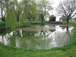
Area of still water surrounded by trees and grass.
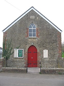
Brewham Baptist Chapel
Duckpond at South Brewham
Brewham is located in Somerset
Brewham
Brewham
Location within Somerset
Population441 (2011)[1]
OS grid referenceST720364
Unitary authority
Ceremonial county
Region
CountryEngland
Sovereign stateUnited Kingdom
Post townBruton
Postcode districtBA10
Dialling code01749
PoliceAvon and Somerset
FireDevon and Somerset
AmbulanceSouth Western
UK Parliament
List of places
UK
England
Somerset
51°07′34″N 2°24′03″W / 51.1261°N 2.4009°W / 51.1261; -2.4009

Brewham is a civil parish in Somerset, England, consisting of the villages of North Brewham and South Brewham, on either side of the river in the Brue Valley 3 miles (4.8 km) east of Bruton and 9 miles (14.5 km) south-west of Frome. The parish has a population of 441.[1]

History

The name of the villages comes from the settlement on the River Brue. In 1066 it was held by Robert son of Wimarc the Staller but after the Norman Conquest was given to William de Moyon is mentioned as a manor belonging to William de Moyon[2] who gave it to his son, William de Mohun of Dunster. Later the manor was given to Bruton Abbey until the Dissolution of the Monasteries when it was granted to Sir Maurice Berkeley.[3]

In 1251 Robert de Musgrove was granted a licence by the king to enlarge Brewham Park, which had previously been held by William de Montacute.[4]

Brewham was part of the hundred of Bruton.[5]

Governance

The parish council has responsibility for local issues, including setting an annual precept (local rate) to cover the council's operating costs and producing annual accounts for public scrutiny. The parish council evaluates local planning applications and works with the local police, district council officers, and neighbourhood watch groups on matters of crime, security, and traffic. The parish council's role also includes initiating projects for the maintenance and repair of parish facilities, as well as consulting with the district council on the maintenance, repair, and improvement of highways, drainage, footpaths, public transport, and street cleaning. Conservation matters (including trees and listed buildings) and environmental issues are also the responsibility of the council.

For local government purposes, since 1 April 2023, the village comes under the unitary authority of Somerset Council. Prior to this, it was part of the non-metropolitan district of South Somerset, which was formed on 1 April 1974 under the Local Government Act 1972, having previously been part of Wincanton Rural District.[6]

The village is part of 'Tower' electoral ward. This ward stretches to Shepton Montague and Cucklington avoiding Wincanton. The total population of the ward at the 2011 census was 2,442.[7]

It is also part of Glastonbury and Somerton county constituency represented in the House of Commons of the Parliament of the United Kingdom. It elects one Member of Parliament (MP) by the first past the post system of election, and was part of the South West England constituency of the European Parliament prior to Britain leaving the European Union in January 2020, which elected seven MEPs using the d'Hondt method of party-list proportional representation.

Geography

North Brewham Meadows is a biological Site of Special Scientific Interest because of the traditionally-managed species-rich meadows which support a neutral grassland community of the nationally rare common knapweed crested dog's-tail type. Breeding butterflies typical of unimproved neutral grassland include small copper (Lycaena phaeas), meadow brown (Maniola jurtina), grayling (Hipparchia semele) and ringlet (Aphantopus hyperantus).[8]

Landmarks

Within the parish and close to the border with Wiltshire is the 49 metres (161 ft) high King Alfred's Tower, a grade I listed building,[9] designed in 1765 by Henry Flitcroft.

Religious sites

The Church of Saint John the Baptist in South Brewham has 13th-century origins, however the current building is largely from the late 19th century.[10]

References

  1. ^ a b "Statistics for Wards, LSOAs and Parishes — SUMMARY Profiles" (Excel). Somerset Intelligence. Retrieved 4 January 2014.
  2. ^ Domesday Book: A Complete Translation. London: Penguin, 2003. ISBN 0-14-143994-7 p. 266
  3. ^ Bush, Robin (1994). Somerset: The complete guide. Wimbourne: Dovecote Press. p. 185. ISBN 1-874336-26-1.
  4. ^ Bond, James (1998). Somerset Parks and Gardens. Somerset Books. p. 25. ISBN 978-0861834655.
  5. ^ "Bruton Hundred". A History of Britain. Retrieved 23 September 2011.
  6. ^ "Wincanton RD". A vision of Britain Through Time. University of Portsmouth. Retrieved 4 January 2014.
  7. ^ "Tower ward 2011". Retrieved 5 March 2015.
  8. ^ "North Brewham Meadows" (PDF). English Nature. Retrieved 18 August 2006.
  9. ^ Historic England. "Alfred's Tower (1175610)". National Heritage List for England. Retrieved 1 April 2008.
  10. ^ Historic England. "Church of Saint John the Baptist (1056463)". National Heritage List for England. Retrieved 28 November 2008.

Media related to Brewham at Wikimedia Commons

Read other articles:

Lilin peringatan yang dinyalakan selama 26 jam Lilin yahrzeit, juga disebut lilin yahrtzeit atau disebut lilin pengenangan, (Ibrani: נר נשמהcode: he is deprecated , ner neshama,[1][2] artinya lilin jiwa; bahasa Yiddi: יאָרצײַט ליכט [yortsayt likht] Error: {{Transl}}: unrecognized language / script code: yid (help), artinya lilin peringatan) adalah sebuah jenis lilin yang dinyalakan dalam memperingati orang mati dalam Yudaisme.[3] Jenis lilin terse...


Lihat pula Daftar pemimpin negara tahun 2011 Kejadian tahun 2012 Daftar pemimpin negara tahun 2013 Pemimpin negara menurut tahun Berikut ini adalah daftar kepala negara, kepala pemerintahan, dan pemimpin negara lain pada tahun 2012. Afrika  Aljazair Presiden – Abdelaziz Bouteflika, Presiden Aljazair (1999–sekarang) Perdana Menteri – Ahmed Ouyahia, Perdana Menteri Aljazair (2008–2012) Abdelmalek Sellal, Perdana Menteri Aljazair (2012–sekarang)  Angola Presiden – Jos...


Badai pasir mendekati Al Asad, Irak, pada 27 April 2005. Badai pasir adalah fenomena meteorologi yang umum di wilayah arid dan semi-arid. Badai pasir antara lain disebabkan oleh meningkatnya kecepatan angin dalam suatu wilayah yang luas. Badai pasir umumnya terjadi pada tanah yang kering. Badai pasir dapat memindahkan keseluruhan bukit pasir dan membawa pasir dalam jumlah besar sehingga tepi badai dapat menyerupai dinding pasir setinggi 1,6 km. Badai pasir di gurun Sahara dalam bahasa se...

Artikel ini memberikan informasi dasar tentang topik kesehatan. Informasi dalam artikel ini hanya boleh digunakan untuk penjelasan ilmiah; bukan untuk diagnosis diri dan tidak dapat menggantikan diagnosis medis. Wikipedia tidak memberikan konsultasi medis. Jika Anda perlu bantuan atau hendak berobat, berkonsultasilah dengan tenaga kesehatan profesional. Ciri-ciri bayi penderita sindrom down. Sindrom Down (Inggris: Down syndromecode: en is deprecated ) merupakan kelainan genetik yang terjadi p...


Biografi ini tidak memiliki sumber tepercaya sehingga isinya tidak dapat dipastikan. Bantu memperbaiki artikel ini dengan menambahkan sumber tepercaya. Materi kontroversial atau trivial yang sumbernya tidak memadai atau tidak bisa dipercaya harus segera dihapus.Cari sumber: Shanker R. S. – berita · surat kabar · buku · cendekiawan · JSTOR (Pelajari cara dan kapan saatnya untuk menghapus pesan templat ini) Shanker RSLahirShanker RS, B.Sc.26 Juli 1966 (u...


This article needs additional citations for verification. Please help improve this article by adding citations to reliable sources. Unsourced material may be challenged and removed.Find sources: Music of the Devil May Cry series – news · newspapers · books · scholar · JSTOR (July 2022) (Learn how and when to remove this template message) The Devil May Cry series has seen the release of seven separate soundtracks. Initially, Capcom was very reluctant t...

Unicode character blockDingbatsRangeU+2700..U+27BF(192 code points)PlaneBMPScriptsCommonAssigned192 code pointsUnused0 reserved code pointsSource standardsITC Zapf Dingbats series 100Unicode version history1.0.0 (1991)160 (+160)3.2 (2002)174 (+14)5.2 (2009)175 (+1)6.0 (2010)191 (+16)7.0 (2014)192 (+1) Unicode documentationCode chart ∣ Web pageNote: [1][2] Dingbats is a Unicode block containing dingbats (or typographical ornaments, like the ❦ FLORAL HEART character). Mo...


Artikel ini bukan mengenai Bahasa Kao. Bahasa Batak KaroBPS: 0018 3 Cakap Karo Bahasa Karo Dituturkan diIndonesiaWilayahSumatera Utara (dataran tinggi Karo)EtnisBatak KaroPenutur600.000 (1991)[1] Rumpun bahasa Austronesia Melayu-Polinesia Sumatra Barat Laut–Kepulauan PenghalangSumatra Barat Laut Varietas bahasa Batak Batak Utara Bahasa Batak Karo Sistem penulisanBatak, LatinKode bahasaISO 639-1bkISO 639-2btkISO 639-3btxGlottologbata1293BPS (2010)0018 3QIDQ124656913 Status ...


Village in SlovakiaRimavská BaňaVillageRimavská BaňaLocation of Rimavská Baňa in the Banská Bystrica RegionShow map of Banská Bystrica RegionRimavská BaňaLocation of Rimavská Baňa in SlovakiaShow map of SlovakiaCoordinates: 48°30′N 19°56′E / 48.500°N 19.933°E / 48.500; 19.933Country SlovakiaRegionBanská BystricaDistrictRimavská SobotaFirst mentioned1334Area • Total26.21[2] km2 (10.12[2] sq mi)Elevati...

ГородМандалговьМандалговьᠮᠠᠨᠳᠠᠯᠭᠣᠪᠢ 45°46′00″ с. ш. 106°16′15″ в. д.HGЯO Страна  Монголия Аймак Дундговь История и география Площадь 11 км² Высота НУМ 1395 м Население Население 10299 человек (2007) Национальности халха-монголы Показать/скрыть карты Мандалговь &#...


Dravidian language of Tulu Nadu region Tuluತುಳು, തുളുTulu Bāse written in Tigalari scriptNative toKarnataka, Northern KeralaRegionTulu Nadu[a][1][2][3]EthnicityTuluvasNative speakers1,850,000 (2011 census)[4]Language familyDravidian South DravidianSouth Dravidian ISouthwestern DravidianKudiya–TuluTuluWriting systemTigalari scriptKannada scriptMalayalam scriptLanguage codesISO 639-3tcyGlottologtulu1258Major Distribution of na...


Pour les articles homonymes, voir Pierre Guillaume et Guillaume. Pierre GuillaumePierre Guillaume en 2003.BiographieNaissance 22 décembre 1940Rambervillers (Vosges)Décès 11 juillet 2023 (à 82 ans)Ambernac (Charente)Nom de naissance Pierre Noël Charles GuillaumePseudonymes Pierre Gaspari, Pierre PithouNationalité françaiseFormation Prytanée national militaire de La FlècheActivité ÉditeurAutres informationsA travaillé pour RivarolCondamné pour Négation de la Shoahmodifier - ...

فرومبيرغ   الإحداثيات 45°23′30″N 108°54′31″W / 45.391666666667°N 108.90861111111°W / 45.391666666667; -108.90861111111   [1] تقسيم إداري  البلد الولايات المتحدة[2]  التقسيم الأعلى مقاطعة كربون  خصائص جغرافية  المساحة 1.16098 كيلومتر مربع1.246711 كيلومتر مربع (1 أبريل 2010)  ارتفاع 107...


Zanzawi Soejoeti [[Rektor Universitas Islam Indonesia]] ke-6Masa jabatan1990 – 1993PendahuluProf. Dr. Ace PartadiredjaPenggantiProf. H. Zaini Dahlan, M.A. Informasi pribadiLahir(1936-08-17)17 Agustus 1936Bantul, Hindia BelandaMeninggal8 Mei 2010(2010-05-08) (umur 73)YogyakartaSuami/istriDra. SuhartatiAnak2KerabatHaryadi Suyuti Ahmad Zahid Hamidi (kerabat)Alma mater Universitas Gadjah Mada University of Wisconsin Sunting kotak info • L • B Prof. Dr. Zanzawi So...


Iranian refugee (1945–2022) Mehran Karimi Nasseriمهران کریمی ناصریNasseri in 2005Born1945 (1945)[1]Masjed Soleiman, Imperial State of IranDied12 November 2022(2022-11-12) (aged 77)Charles de Gaulle Airport, Le Mesnil-Amelot, FranceOther namesSir, Alfred MehranCitizenshipIran (until 1977)Stateless (from 1977) Mehran Karimi Nasseri (Persian: مهران کریمی ناصری, pronounced [mehˈrɒn kæriˈmi nɒseˈri]; 1945 – 12 November 2022), a...

Overview of the presence of Indian nationals and citizens in Afghanistan Ethnic group Indians in AfghanistanRegions with significant populationsKabul · JalalabadLanguagesHindi · English · Punjabi · Pashto · Persian (Dari) · Urdu · other Indian languagesReligionHinduism · Sikhism · IslamRelated ethnic groupsIndian diaspora, Hindkowans, Potoharis, Rajputs, Jats,...


RubyDirancang olehYukihiro MatsumotoPengembangYukihiro Matsumoto (dengan yang lain)Rilis perdana1995Tipe sistemdinamis (duck)Sistem operasiLintas anjunganLisensiRuby LicenseGNU General Public LicenseSitus webhttp://www.ruby-lang.org/Repositoriwww.ruby-lang.orgImplementasi utamaRuby MRI, JRuby, Rubinius. MacRuby, YARV, IronRubyTerpengaruh olehSmalltalk, Perl, Lisp, Scheme, Python, CLU, Eiffel, Ada, DylanMempengaruhiGroovySunting kotak info • L • BBantuan penggunaan temp...


لو يوان بوولنجر (بالفرنسية: Yoann Le Boulanger)‏  معلومات شخصية الميلاد 4 نوفمبر 1975 (العمر 48 سنة)غانغان، فرنسا الطول 1.85 م (6 قدم 1 بوصة) الجنسية  فرنسا الوزن 70 كـغ (150 رطل) الحياة العملية الدور دراج الفرق كوفيديس (2000–2001)ديركت إينرجي (2006–2007)إف دي جي (2008–2008)  المهنة در...

طابعة ليزر من إنتاج شركة هولت باكارد طابعة الليزر هي نوع من أشهر أنواع الطابعات الحاسوبية حيت تتميز بقدرتها على طباعة النصوص والرسوم بجودة عالية وبشكل سريع نسبياً.[1][2][3] وتشبه طابعة الليزر آلة تصوير المستندات في أن كلاهما يعتمد على أسلوب الطباعة الإلكترونى، ف�...


Val-CeniscomuneVal-Cenis – VedutaVillaggio di Bramans LocalizzazioneStato Francia RegioneAlvernia-Rodano-Alpi Dipartimento Savoia ArrondissementSaint-Jean-de-Maurienne CantoneModane AmministrazioneData di istituzione1º gennaio 2017 TerritorioCoordinate45°16′42″N 6°49′04″E45°16′42″N, 6°49′04″E (Val-Cenis) Superficie408,05 km² Abitanti2 136 (2018) Densità5,23 ab./km² Altre informazioniCod. postale73500 Fuso orarioUTC+1 Codice INSEE73290 Cartografia...