Ma'alul (bahasa Arab : معلول ) adalah sebuah desa yang utamanya terdiri dari Kristen Palestina . Desa tersebut dikosongkan dan dihancurkan oleh Israel pada Perang Arab-Israel 1948 . Berjarak enam kilometer dari barat kota Nazareth ,[ 7] [ 8] Yafa an-Naseriyye .[ 9]
Referensi
^ Palmer, 1881, p. 113
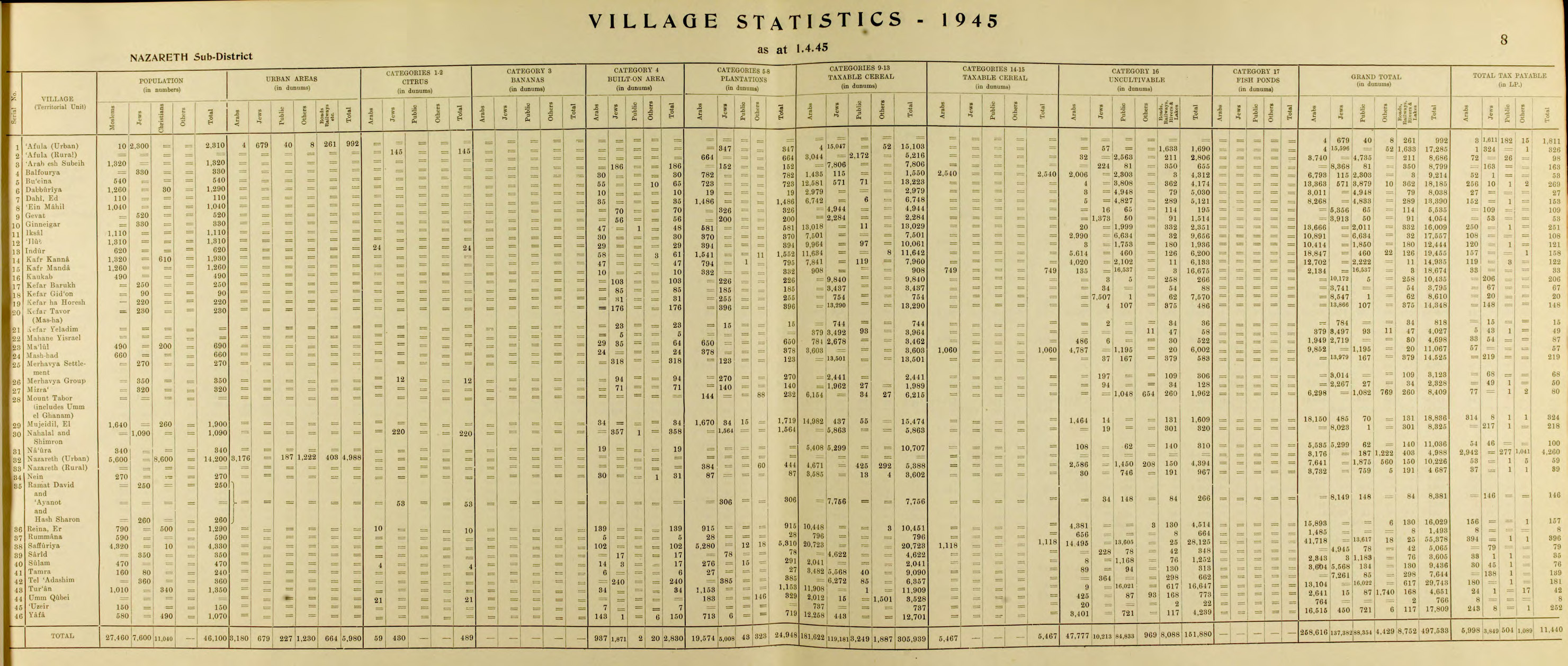
^ a b Government of Palestine, Department of Statistics. Village Statistics, April, 1945. Quoted in Hadawi, 1970, p. 62
^ Department of Statistics, 1945, p. 8
^ Morris, 2004, p. xvii , village #138. Also gives cause of depopulation.
^ Morris, 2004, p. xx , settlement #12.
^ Khalidi, 1992, p. 347
^ Ma'lul , diakses tanggal 2008-03-31 ^ Rabinowitz, 1997, p. 27
^ Nihad Bokae'e (February 2003), Palestinian Internally Displaced Persons inside Israel:Challenging the Solid Structures (PDF) , Badil , diarsipkan dari asli (PDF) tanggal June 14, 2007
Daftar pustaka
Barron, J. B., ed. (1923). Palestine: Report and General Abstracts of the Census of 1922 Conder, C.R. ; Kitchener, H.H. (1881). The Survey of Western Palestine: Memoirs of the Topography, Orography, Hydrography, and Archaeology Committee of the Palestine Exploration Fund .Department of Statistics (1945). Village Statistics, April, 1945 De Haas, J. (1934). History of Palestine - The Last Two Thousand Years Guérin, V. (1880). Description Géographique Historique et Archéologique de la Palestine Pemeliharaan CS1: Bahasa yang tidak diketahui (link ) Hadawi, S. (1970). Village Statistics of 1945: A Classification of Land and Area ownership in Palestine Hütteroth, Wolf-Dieter; Abdulfattah, Kamal (1977). Historical Geography of Palestine, Transjordan and Southern Syria in the Late 16th Century ISBN 3-920405-41-2 Karmon, Y. (1960). "An Analysis of Jacotin's Map of Palestine" (PDF) . Israel Exploration Journal . 10 (3, 4): 155– 173, 244– 253. Diarsipkan dari asli (PDF) tanggal 2019-12-22. Diakses tanggal 2020-07-26 . Keil, C.F. (1865). Joshua, Judges, Ruth, tr. by J. Martin Khalidi, W. (1992). All That Remains: The Palestinian Villages Occupied and Depopulated by Israel in 1948 Washington D.C. : Institute for Palestine Studies . ISBN 0-88728-224-5 Mills, E., ed. (1932). Census of Palestine 1931. Population of Villages, Towns and Administrative Areas Morris, B. (2004). The Birth of the Palestinian Refugee Problem Revisited Cambridge University Press . ISBN 978-0-521-00967-6 Palmer, E. H. (1881). The Survey of Western Palestine: Arabic and English Name Lists Collected During the Survey by Lieutenants Conder and Kitchener, R. E. Transliterated and Explained by E.H. Palmer Committee of the Palestine Exploration Fund .Pappé, I. (2006). The Ethnic Cleansing of Palestine ISBN 1-85168-467-0 Rabinowitz, Dan (1997). Overlooking Nazareth: The Ethnography of Exclusion in Galilee Cambridge University Press . ISBN 0-521-56495-6 Rhode, H. (1979). Administration and Population of the Sancak of Safed in the Sixteenth Century Columbia University . Diarsipkan dari asli tanggal 2019-04-20. Diakses tanggal 2020-07-26 .Schumacher, G. (1888). "Population list of the Liwa of Akka" . Quarterly statement - Palestine Exploration Fund . 20 : 169– 191.Schwarz, Joseph (1850). A Descriptive Geography and Brief Historical Sketch of Palestine
Pranala luar


