24°35′28″N 121°8′53″E / 24.59111°N 121.14806°E / 24.59111; 121.14806
Mountain indigenous township
Wufeng Township
五峰鄉 |
|---|
|
![]() |
 Wufeng Township in Hsinchu County |
| Location | Hsinchu County, Taiwan |
|---|
|
• Total | 228 km2 (88 sq mi) |
|---|
|
• Total | 4,488 |
|---|
| • Density | 20/km2 (51/sq mi) |
|---|
| Website | www.hcwft.gov.tw  (in Chinese) (in Chinese) |
|---|
Wufeng Township (Chinese: 五峰鄉; pinyin: Wǔfēng Xiāng) is a mountain indigenous township in Hsinchu County, Taiwan.
It had an estimated population of 4,488 as of March 2023.[1]
The population is mainly of the indigenous Atayal people and Saisiyat people.[2][3]
Administrative divisions
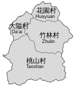
 Administrative divisions of Wufeng Township
The township comprises four villages: Daai, Huayuan, Taoshan and Zhulin.
Tourist attractions
Climate
| Climate data for Wufeng Agricultural Research and Extension Station, elevation 1,048 m (3,438 ft), (1991–2020, extremes 1995–present)
|
| Month
|
Jan
|
Feb
|
Mar
|
Apr
|
May
|
Jun
|
Jul
|
Aug
|
Sep
|
Oct
|
Nov
|
Dec
|
Year
|
| Record high °C (°F)
|
28.4
(83.1)
|
31.3
(88.3)
|
30.5
(86.9)
|
30.8
(87.4)
|
31.4
(88.5)
|
33.4
(92.1)
|
35.5
(95.9)
|
32.2
(90.0)
|
31.4
(88.5)
|
32.3
(90.1)
|
29.8
(85.6)
|
26.0
(78.8)
|
35.5
(95.9)
|
| Mean daily maximum °C (°F)
|
15.3
(59.5)
|
16.3
(61.3)
|
18.6
(65.5)
|
21.5
(70.7)
|
24.1
(75.4)
|
26.3
(79.3)
|
27.2
(81.0)
|
26.4
(79.5)
|
25.0
(77.0)
|
22.5
(72.5)
|
20.3
(68.5)
|
16.7
(62.1)
|
21.7
(71.0)
|
| Daily mean °C (°F)
|
10.8
(51.4)
|
11.8
(53.2)
|
13.9
(57.0)
|
17.1
(62.8)
|
19.8
(67.6)
|
21.8
(71.2)
|
22.4
(72.3)
|
22.0
(71.6)
|
20.8
(69.4)
|
18.2
(64.8)
|
16.0
(60.8)
|
12.3
(54.1)
|
17.2
(63.0)
|
| Mean daily minimum °C (°F)
|
8.0
(46.4)
|
8.9
(48.0)
|
10.7
(51.3)
|
14.1
(57.4)
|
17.0
(62.6)
|
19.0
(66.2)
|
19.6
(67.3)
|
19.4
(66.9)
|
18.2
(64.8)
|
15.6
(60.1)
|
13.2
(55.8)
|
9.6
(49.3)
|
14.4
(58.0)
|
| Record low °C (°F)
|
−4.0
(24.8)
|
−1.2
(29.8)
|
−0.3
(31.5)
|
2.8
(37.0)
|
11.6
(52.9)
|
12.2
(54.0)
|
16.5
(61.7)
|
17.3
(63.1)
|
12.6
(54.7)
|
7.4
(45.3)
|
2.3
(36.1)
|
−1.3
(29.7)
|
−4.0
(24.8)
|
| Average precipitation mm (inches)
|
107.5
(4.23)
|
156.9
(6.18)
|
186.2
(7.33)
|
194.6
(7.66)
|
272.3
(10.72)
|
295.2
(11.62)
|
345.2
(13.59)
|
478.6
(18.84)
|
335.6
(13.21)
|
138.0
(5.43)
|
67.3
(2.65)
|
87.2
(3.43)
|
2,664.6
(104.89)
|
| Average relative humidity (%)
|
86.3
|
87.6
|
88.7
|
88.1
|
88.8
|
87.2
|
86.7
|
89.7
|
88.7
|
87.6
|
85.4
|
85.1
|
87.5
|
| Source: Central Weather Administration[5]
|
References
External links
|
|---|
Urban
townships | |
|---|
Rural
townships | |
|---|
Mountain
indigenous
townships | |
|---|
Note: Pinyin is the national standard and promulgated by the Ministry of Interior. Exceptions: "Lukang" instead of "Lugang" and names of Counties. |