Share to: share facebook share twitter share wa share telegram print page

Welsh St Donats

Welsh St Donats
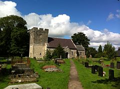
St Donat's (St Dunwyd's) church
Welsh St Donats is located in Vale of Glamorgan
Welsh St Donats
Welsh St Donats
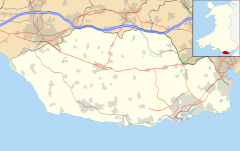
Location within the Vale of Glamorgan
Population534 
Principal area
Preserved county
CountryWales
Sovereign stateUnited Kingdom
Post townCowbridge
Postcode districtCF71
Dialling code01446
PoliceSouth Wales
FireSouth Wales
AmbulanceWelsh
UK Parliament
Senedd Cymru – Welsh Parliament
List of places
UK
Wales
Vale of Glamorgan
51°28′30″N 3°24′04″W / 51.475088°N 3.401187°W / 51.475088; -3.401187

Welsh St Donats (Welsh: Llanddunwyd) is a village and a community in the Vale of Glamorgan, Wales. Consisting of 1207 hectares of mainly rural land, it is located north east of Cowbridge. The population of the community was 534 in the 2011 census.[1] Welsh St Donats includes the villages of Maendy, Prisk and Tair Onen.[2] A mile to the east from the village lies the Hensol Forest, while the remains of Talyfan Castle are to the north.

History

The village of St Donats takes its name from the late medieval church dedicated to St Dunwyd, which was first mentioned in 1173.[3] Set in mainly agricultural lands the compact village contains the 18th century Great House and a fine farm group.[4] Benjamin Heath Malkin mentions Welsh St Donats in his 1803 work The Scenery, Antiquities and Biography of South Wales, while passing along the 'great road' that ran north of the village, which linked England to the port of Milford Haven. He mentioned the varying style of genuine Welsh pigstye in the area and the fact that Welsh St Donats "... is perhaps scarcely a village in the principality, where less English is spoken."[5] As of 2019, spoken Welsh in the Vale is one of the lowest levels in Wales, with less than ten percent of adults identifying themselves as Welsh speakers.[6]

Buildings of note

St Donat's Church, Welsh St Donats, is a Grade I listed building. It was described by Nikolaus Pevsner as "a simple late mediaeval church" despite being mentioned in 1173. However there are no architectural remains in the present structure from that period.[7][8] The 16th century arched brace truss roof timbers and other features, such as the 13th century font to the south door, are of interest and note and therefore contribute to it being a Grade I listed building.[9]

The church sits to the north end of a knot of houses, mostly recent, and within the middle of these lies the Great House. The Great House, is a two-storey 18th-century building of modest features consisting of three, three-bay units, the centre of which is higher than the sides.[9] Prisk Farm, which is situated about a mile to the west, once boasted an elaborate modelled plaster ceiling, of 17th- or 18th-century design. Unique amongst the farm houses of the area, the ceiling was lost when it collapsed c. 1989.[9]

To the north of Welsh St Donats lies the remains of Talyfan Castle (Welsh: Castell Tal-y-fan). Once serving as a caput for the Siwards and the St Quintins, Talyfan was one of several lordships within the Vale of Glamorgan during the 12th and 13th centuries.[10] There is some speculation that it was built to replace the motte castle at Ystradowen, but was never completed.[10] By the middle of the 13th century the castle had passed from the Siwards to the ownership of Richard de Clare, Lord of Glamorgan. The Lords of Glamorgan held onto the castle the late 15th century when it reverted to the monarchy after the death of Jasper Tudor.[10] It was bought by John Thomas Bassett of Llantrithyrd in 1545 and remained in private hands since. Today the remains of the castle stand on the lands of Talyfan Farm, though there is little left to see.[10] The original protective ditch can be observed along with a length of the outer embankment. A jumble of ruined walls mark the remains of the castle itself along with those of the farm house that superseded it. It is presently under the ownership of CADW.[10]

Notable people

See also

References

  1. ^ UK Census (2011). "Local Area Report – Welsh St. Donats Parish (W04000923)". Nomis. Office for National Statistics. Retrieved 6 May 2020.{{cite web}}: CS1 maint: date and year (link)
  2. ^ http://www.welsh-st-donats-community.btck.co.uk/ Community website. Accessed 17 May 2014
  3. ^ "Church of St Donat, Welsh St Donats". British Listed Buildings. Retrieved 21 March 2020.
  4. ^ Davies, John; Jenkins, Nigel; Menna, Baines; Lynch, Peredur I., eds. (2008). The Welsh Academy Encyclopaedia of Wales. Cardiff: University of Wales Press. p. 943. ISBN 978-0-7083-1953-6.
  5. ^ Prys Morgan, ed. (1988). Glamorgan County History. Cardiff: University of Wales Press. pp. 273–274. ISBN 978-0-904-730-05-0.
  6. ^ "Percentage of adults who speak Welsh (including the percentage that cannot speak Welsh and have some Welsh speaking ability) by local authority". StatsWales. Retrieved 21 March 2020.
  7. ^ http://www.eastvalechurches.org.uk /ChurchWelshStDonats.html East Vale Churches website. Accessed 17 May 2014.
  8. ^ "Church of St Donat, Welsh St Donats". British Listed Buildings. Retrieved 22 July 2015.
  9. ^ a b c Newman, John (1995). Glamorgan. London: Penguin Group. p. 644. ISBN 0140710566.
  10. ^ a b c d e Hull, Lise (2007). The Castles of Glamorgan. Herefordshire: Logaston Press. pp. 223–225. ISBN 978-1904396-75-8.
  11. ^ Jones, Sir Tom (2015). Over the Top and Back: The Autobiography. Penguin. ISBN 978-06984-0930-9.

This information is adapted from Wikipedia which is publicly available.

Read other articles:

آيت امحند أوبولمان تقسيم إداري البلد المغرب  الجهة بني ملال خنيفرة الإقليم بني ملال الدائرة أغبالة الجماعة القروية بوتفردة المشيخة آيت بولمان السكان التعداد السكاني 501 نسمة (إحصاء 2004)   • عدد الأسر 86 معلومات أخرى التوقيت ت ع م±00:00 (توقيت قياسي)[1]،  وت ع م+01:00 (توقيت

New Mexico Territory's at-large congressional districtObsolete districtCreated1851, as a non-voting delegate was granted by CongressEliminated1912, as a result of statehoodYears active1851–1912 New Mexico Territory with its final borders in 1866 New Mexico Territory's at-large congressional district is an obsolete congressional district representing the New Mexico Territory, which was created in 1850. After New Mexico's admission to the Union as the 47th state by act of Congress on January 6, …

Boat rescue craft which is used to attend a vessel in distress For a shipboard vessel designed to provide emergency escape, see Lifeboat (shipboard). This article includes a list of general references, but it lacks sufficient corresponding inline citations. Please help to improve this article by introducing more precise citations. (January 2011) (Learn how and when to remove this template message) A rescue lifeboat is a boat rescue craft which is used to attend a vessel in distress, or its survi…

Wycker Kruittoren Sint-Maartenspoort, Sint-Maartenskerk en Wycker Kruittoren vanuit het noorden (A. Schaepkens, ca. 1840) Locatie Locatie Maastricht (Oeverwal, Wyck) Status en tijdlijn Oorspr. functie waltoren Start bouw 14e eeuw? Sluiting 1868 (sloop) Wycker stadsmuur met locatie Wycker Kruittoren (1) Portaal    Maastricht De Wycker Kruittoren, ook wel toren aan de lage Maaspunt of Woutersrondeel genoemd, was een van oorsprong middeleeuwse waltoren, later kruittoren, in de Nederl…

Mataiva Mataiva Coordenadas: 14° 53' S 148° 43' O Geografia física País Polinésia Francesa Arquipélago Tuamotu Gambier Área 16  km² Geografia humana População 204 (2007) Densidade 12,8  hab./km² Mataiva é uma das ilhas do arquipélago de Tuamotu-Gambier, pertencente ao Taiti.[1] Referências ↑ Mataiva, Eden des Tuamotu Arquivado em [Falta data] no Portuguese Web Archive Publisher: Air Tahiti: Polynesian Airline - News (in French). Author: Jean-François Butaud…

VlagUSS Gerald R. Ford (CVN-78)Vlag USS Gerald R. Ford bij Newport News Shipbuilding Overzicht Type Supervliegdekschip Naamsein CVN-78 Naamgever president Gerald Ford Geschiedenis Besteld 10 september 2008 Werf Northrop Grumman Newport News Kiellegging 13 september 2009 Tewaterlating 9 september 2013 In dienst gesteld 22 juli 2017 Algemene kenmerken Waterverplaatsing 101.600 ton Lengte 337 m Breedte Vliegdek: 78 mWaterlijn: 41 m Diepgang 12 m Bemanning 4297[1] Techniek en uitrusting Mach…

Cosmopolitan TV Eslogan Inevitablemente CosmoTipo de canal Televisión por suscripciónProgramación Estilos de vidaPropietario Hearst Corporation(2002-2012)Pramer(2002-2013)Chello Latin America(2013-2014)AMC Networks International(2014-2015)Operado por Pramer(2002-2013)Chello Latin America(2013-2014)AMC Networks International Latin America(2014-2015)País  ArgentinaFundación 1 de julio de 2002Fundador Hearst CorporationPramerInicio de transmisiones 1 de julio de 2002Cese de transmisiones …

اللؤلؤ المكنون في سيرة النبي المأمون اللؤلؤ المكنون في سيرة النبي المأمون: دراسة محققة للسيرة النبوية معلومات الكتاب المؤلف موسي راشد العازمي البلد الكويت اللغة العربية تاريخ النشر 1432 هـ - 2011 م النوع الأدبي السيرة النبوية التقديم عدد الأجزاء 4 مجلدات المواقع ردمك 6 - 01 - 44 - 99966…

ソマリア沖にて商船直接護衛を行うDSPE部隊の護衛艦「せとぎり」 ソマリア沖海賊の対処活動(ソマリアおきかいぞくたいしょかつどう、Deployment Surface Force Counter Piracy Enforcement, DSPE)は、ソマリア沖やアデン湾で活動するソマリア沖の海賊の海賊行為から付近を航行する船舶を護衛する目的で行われる自衛隊海外派遣である。海上保安官を同乗させた海上自衛隊の護衛艦が…

Constitution of Australia Chapters of the Constitution Chapter I: The Parliament Chapter II: The Executive Government Chapter III: The Judicature Chapter IV: Finance and Trade Chapter V: The States Chapter VI: New States Chapter VII: Miscellaneous Chapter VIII: Alteration of the Constitution Text of the Constitution The full text of Constitution of Australia at Wikisource  Australia portalvte Section 119 of the Constitution of Australia requires the federal government to protect the sta…

Konferensi Meridian Internasional (Inggris: International Meridian Conference) adalah konferensi yang diadakan pada Oktober 1884 di Washington, D.C., Amerika Serikat untuk menentukan Meridian utama dunia. Konferensi ini diadakan atas permintaan presiden Amerika Serikat Chester A. Arthur. 25 negara (Austria-Hungaria, Brasil, Chili, Kolombia, Kosta Rika, Denmark, Prancis, Jerman, Britania Raya, Guatemala, Hawaii, Italia, Jepang, Meksiko, Belanda, Paraguay, Rusia, San Domingo, Salvador, Spanyol, Sw…

Turkish economist Dani RodrikRodrikBorn (1957-08-14) August 14, 1957 (age 66)Istanbul, TurkeyCitizenshipTurkishAcademic careerInstitutionInstitute for Advanced StudyFieldInternational economics, economic development, political economyAlma materRobert CollegePrinceton University (PhD, MPA)Harvard University (AB)DoctoraladvisorAvinash Dixit[1]AwardsLeontief Prize for Advancing the Frontiers of Economic Thought (2002)Information at IDEAS / RePEc Dani Rodrik (born August …

Independent trade publisher Arcade PublishingParent companySkyhorse PublishingFounded1988FounderRichard Seaver and Jeannette SeaverCountry of originUnited StatesPublication typesBooksOfficial websitewww.arcadepub.com Arcade Publishing is an imprint of the American book publisher Skyhorse. Founded in 1988 by Richard Seaver and his wife Jeannette, it was originally an independent company publishing trade fiction and nonfiction.[1][2] After declaring bankruptcy following Richard's d…

Artikel ini sebatang kara, artinya tidak ada artikel lain yang memiliki pranala balik ke halaman ini.Bantulah menambah pranala ke artikel ini dari artikel yang berhubungan atau coba peralatan pencari pranala.Tag ini diberikan pada Oktober 2022. Kasus pencurian pulsa 2011 mengacu kepada serangkaian perjalanan kasus yang berkaitan dengan pencurian pulsa oleh Colibri Networks yang dipimpin Nirmal Hiroo Bharwani alias HB Naveen. Pelaporan Pada 5 Oktober 2011, Mohammad Feri Kuntoro melaporkan Colibri…

Tavern in New York City 40°44′09″N 74°00′21″W / 40.73583°N 74.00583°W / 40.73583; -74.00583 The White Horse Tavern in 1961 The interior in January 2007 The White Horse Tavern, located in New York City's borough of Manhattan at Hudson Street and 11th Street, is known[by whom?] for its 1950s and 1960s bohemian culture. It is one of the few major gathering-places for writers and artists from this period in Greenwich Village (specifically the West Village)…

Bangladeshi television channel Television channel Ekushey Televisionএকুশে টেলিভিশনThe headquarters of Ekushey Television in Kawran BazarCountryBangladeshBroadcast areaNationwideWorldwide (via online)HeadquartersKawran Bazar, DhakaProgrammingPicture format576i SDTVOwnershipOwnerS. Alam Group of Industries[1]Key peopleMohammed Saiful Alam (chairman)Pijush Bandyopadhyay (CEO)[2]Sister channelsNexus TelevisionHistoryLaunched14 April 2000; 23 yea…

Sair Tjerita Siti Akbari Cetakan ketiga, 1922PengarangLie Kim HokNegaraHindia BelandaBahasaMelayu RendahGenreSyairPenerbitW. Bruining & Co.Tanggal terbit1884Halaman200OCLC318099218 Sair Tjerita Siti Akbari (EYD: Syair Cerita Siti Akbari; juga dikenal hanya sebagai Siti Akbari) adalah syair berbahasa Melayu karangan Lie Kim Hok yang diterbitkan pada tahun 1884. Diadaptasi dari Sjair Abdoel Moeloek, syair ini bercerita tentang seorang wanita yang menyamar sebagai lelaki untuk membebaskan …

Aboriginal Australian Indigenous rights activist Daisy Bindi (1904—1962), also known as Mumaring, was an Aboriginal Australian Indigenous rights activist and a leader in the landmark 1946 Pilbara strike in Western Australia. Early life Bindi was born about 1904 on a cattle-station near present-day Jigalong, on the edge of the Gibson Desert in Western Australia, to parents Jimmy and Milly.[1][2] Her Aboriginal name was Mumaring.[1] She acquired the name Bindi on her marr…

Wapen van het Heilige Roomse Rijk met bovenaan de wapens van de keurvorsten. Met de term Kur werd in het Heilige Roomse Rijk de verkiezingsbijeenkomst voor de aanduiding van de nieuwe Rooms-Duitse koning respectievelijk keizer bedoeld. Dit woord is afgeleid van het Middelhoogduitse kur respectievelijk kure (keus, keuze). Aanvankelijk waren alle zogenaamde Großen des Reiches (rijksgroten; rijksvorsten) gerechtigd om aan de koningskeuze deel te nemen, sinds de tweede helft van de 13e eeuw was dit…

Artificial pond usually sited on the top of a hill, intended for watering livestock. Typical example of downland dew pond near Chanctonbury Ring, West Sussex.50°53′47″N 0°23′23″W / 50.896293°N 0.389756°W / 50.896293; -0.389756 A dew pond is an artificial pond usually sited on the top of a hill, intended for watering livestock. Dew ponds are used in areas where a natural supply of surface water may not be readily available. The name dew pond (sometimes cloud po…

Kembali kehalaman sebelumnya

Lokasi Pengunjung: 3.128.204.131