Coudekerque-Village

Coudekerque-Village
Koudekerke-Dorp, Koukerke (West Flemish)
Location of Coudekerque-Village in the arrondissement of Dunkirk
Location of Coudekerque-Village
Map
Coudekerque-Village is located in France
Coudekerque-Village
Coudekerque-Village
Coudekerque-Village is located in Hauts-de-France
Coudekerque-Village
Coudekerque-Village
Coordinates: 50°59′42″N 2°25′01″E / 50.995°N 2.417°E / 50.995; 2.417
CountryFrance
RegionHauts-de-France
DepartmentNord
ArrondissementDunkerque
CantonCoudekerque-Branche
CommuneTéteghem-Coudekerque-Village
Area
1
12.03 km2 (4.64 sq mi)
Population
 (2019)[1]
1,380
 • Density110/km2 (300/sq mi)
Time zoneUTC+01:00 (CET)
 • Summer (DST)UTC+02:00 (CEST)
Postal code
59380
Elevation0–13 m (0–43 ft)
(avg. 1 m or 3.3 ft)
1 French Land Register data, which excludes lakes, ponds, glaciers > 1 km2 (0.386 sq mi or 247 acres) and river estuaries.

Coudekerque-Village (Dutch: Koudekerke-Dorp; West Flemish: Koukerke-Dorp) is a former commune of the Nord department in northern France.[2] On 1 January 2016, it was merged into the new commune Téteghem-Coudekerque-Village.[3] Prior to October 6, 2008, it was known as Coudekerque (Koudekerke).[4] The name was changed to distinguish it from Coudekerque-Branche.

Town hall

Heraldry

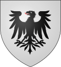
Arms of Coudekerque-Village
The arms of Coudekerque-Village are blazoned :
Argent, an eagle sable, langued gules.


See also

References