St. Augustine |
|---|
|
 |
 Coat of arms |
| Nickname(s): Ancient City, Old City |
 |
Location in the United States |
| Coordinates: 29°53′41″N 81°18′52″W / 29.89472°N 81.31444°W / 29.89472; -81.31444[1] |
| Country | United States |
|---|
| State | Florida |
|---|
| County | St. Johns |
|---|
| Established | September 8, 1565; 459 years ago (1565-09-08) |
|---|
| Founded by | Pedro Menéndez de Avilés |
|---|
| Named for | Saint Augustine of Hippo |
|---|
|
| • Type | City commission government |
|---|
|
| • City | 12.85 sq mi (33.29 km2) |
|---|
| • Land | 9.52 sq mi (24.66 km2) |
|---|
| • Water | 3.33 sq mi (8.63 km2) |
|---|
| Elevation | 0 ft (0 m) |
|---|
|
| • City | 14,329 |
|---|
| • Density | 1,504.99/sq mi (581.05/km2) |
|---|
| • Urban | 91,786 |
|---|
| Time zone | UTC−5 (EST) |
|---|
| • Summer (DST) | UTC−4 (EDT) |
|---|
| ZIP code(s) | 32080, 32084, 32085, 32086, 32095, 32082, 32092 |
|---|
| Area code | 904 |
|---|
| FIPS code | 12-62500[5] |
|---|
| GNIS feature ID | 0308101[3] |
|---|
| Website | City of St. Augustine |
|---|
St. Augustine is the oldest city in the United States begun by Europeans and filled with people since it was started. The admiral from Spain, Pedro Menéndez de Avilés, started St. Augustine in 1565. There was fighting between England and Spain in 1586, 1702, and 1740 over the city. Spain won each time. In 1763, St. Augustine was given to the English as part of the Treaty of Paris which ended the French and Indian War. After the American colonies became independent from England, another Treaty of Paris, this one in 1783, returned the area to Spain. In 1819, the Adams-Onís Treaty gave all of Florida to the United States.
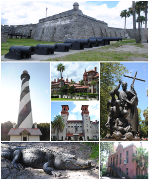
The largest sign of the years under Spain is the Castillo de San Marcos, a large masonry fort built between 1672 and 1695. This fort still stands.
References
Other websites
 Media related to St. Augustine, Florida at Wikimedia Commons