| This article does not have any sources. You can help Wikipedia by finding good sources, and adding them. (July 2010) |
Schwanden |
|---|
|
 Coat of arms |
|
Show map of Canton of Glarus |
| Coordinates: 47°00′N 9°04′E / 47.000°N 9.067°E / 47.000; 9.067 |
| Country | Switzerland |
|---|
| Canton | Glarus |
|---|
| District | n.a. |
|---|
|
| • Total | 30.63 km2 (11.83 sq mi) |
|---|
| Elevation | 521 m (1,709 ft) |
|---|
|
| • Total | 2,557 |
|---|
| • Density | 83/km2 (220/sq mi) |
|---|
| Time zone | UTC+01:00 (Central European Time) |
|---|
| • Summer (DST) | UTC+02:00 (Central European Summer Time) |
|---|
| Postal code(s) | 8762 |
|---|
| SFOS number | 1627 |
|---|
| Surrounded by | Elm, Engi, Glarus, Haslen, Luchsingen, Matt, Mitlödi, Nidfurn, Schwändi, Sool |
|---|
| Website | www.schwanden.ch
SFSO statistics |
|---|
Schwanden was a municipality, in the municipality of Glarus Süd and canton of Glarus in Switzerland. The lake Garichtisee can be reached by cable car.
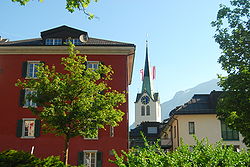
 Church of Schwanden
Other websites
 Media related to Schwanden at Wikimedia Commons
|
|---|
| Municipalities from January 1, 2011 | | |
|---|
| Former municipalities | |
|---|
|