Saint-Étienne-en-Dévoluy |
|---|
|
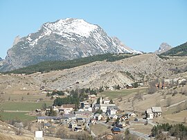
 The village of Saint-Étienne-en-Dévoluy, with the south face of Le Gicon in the background |
 Coat of arms |
Location of Saint-Étienne-en-Dévoluy |
Show map of Provence-Alpes-Côte d'Azur |
| Coordinates: 44°41′36″N 5°56′31″E / 44.6933°N 5.9419°E / 44.6933; 5.9419 |
| Country | France |
|---|
| Region | Provence-Alpes-Côte d'Azur |
|---|
| Department | Hautes-Alpes |
|---|
| Arrondissement | Gap |
|---|
| Canton | Saint-Étienne-en-Dévoluy |
|---|
| Commune | Le Dévoluy |
|---|
| Area 1 | 67.87 km2 (26.20 sq mi) |
|---|
| Population | 502 |
|---|
| • Density | 7.4/km2 (19/sq mi) |
|---|
| Time zone | UTC+01:00 (CET) |
|---|
| • Summer (DST) | UTC+02:00 (CEST) |
|---|
| Postal code | 05250 |
|---|
| Elevation | 1,134–2,652 m (3,720–8,701 ft)
(avg. 1,263 m or 4,144 ft) |
|---|
| 1 French Land Register data, which excludes lakes, ponds, glaciers > 1 km2 (0.386 sq mi or 247 acres) and river estuaries. |
Saint-Étienne-en-Dévoluy used to be a commune in the Hautes-Alpes department. On 1 January 2013, it became part of the new commune of Le Dévoluy.
References