|
Rogers County, Oklahoma
Rogers County |
|---|
|
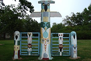
 Ed Galloway's Totem Pole Park |
 Flag  Seal |  Location within the U.S. state of Oklahoma |  Oklahoma's location within the U.S. | | Coordinates: 36°18′38.35″N 95°37′1.48″W / 36.3106528°N 95.6170778°W / 36.3106528; -95.6170778 | | Country |  United States United States |
|---|
| State |  Oklahoma Oklahoma |
|---|
| Founded | January 26, 1907 |
|---|
| Named for | Clement Vann Rogers |
|---|
| Seat | Claremore |
|---|
| Largest city | Claremore |
|---|
| Other cities | Catoosa, Collinsville, Owasso, Tulsa |
|---|
|
| • Total | 711 sq mi (1,840 km2) |
|---|
| • Land | 676 sq mi (1,750 km2) |
|---|
| • Water | 36 sq mi (90 km2) 5.0% |
|---|
|
| • Total | 95,240 [1] |
|---|
| • Density | 140.9/sq mi (54.4/km2) |
|---|
| Time zone | UTC−6 (Central) |
|---|
| • Summer (DST) | UTC−5 (CDT) |
|---|
| ZIP Codes | 74015, 74016, 74017, 74018, 74019, 74031, 74036, 74053, 74080 |
|---|
| Area code | 539, 918 |
|---|
| Congressional districts | 1st, 2nd |
|---|
| Website | www.rogerscounty.org |
|---|
Rogers County is a county in the U.S. state of Oklahoma. As of 2020, 95,240 people lived there.[1] Its county seat is Claremore.
Geography
The county has a total area of 711 square miles.
Bordering counties
Cities and towns
NRHP sites
The followings sites in Rogers County are listed on the National Register of Historic Places:
References
|
|