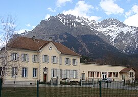
Les Costes |
|---|
|
 The town hall, with the Banc du Peyron in the background |
|
Show map of Provence-Alpes-Côte d'Azur |
| Coordinates: 44°44′48″N 6°02′05″E / 44.7467°N 6.0347°E / 44.7467; 6.0347 |
| Country | France |
|---|
| Region | Provence-Alpes-Côte d'Azur |
|---|
| Department | Hautes-Alpes |
|---|
| Arrondissement | Gap |
|---|
| Canton | Saint-Bonnet-en-Champsaur |
|---|
| Commune | Aubessagne |
|---|
| Area 1 | 8.78 km2 (3.39 sq mi) |
|---|
| Population | 178 |
|---|
| • Density | 20/km2 (53/sq mi) |
|---|
| Time zone | UTC+01:00 (CET) |
|---|
| • Summer (DST) | UTC+02:00 (CEST) |
|---|
| Postal code | 05500 |
|---|
| Elevation | 1,043–2,776 m (3,422–9,108 ft)
(avg. 1,110 m or 3,640 ft) |
|---|
| 1 French Land Register data, which excludes lakes, ponds, glaciers > 1 km2 (0.386 sq mi or 247 acres) and river estuaries. |
Les Costes is a former commune in the Hautes-Alpes department. It is now part of Aubessagne.
Population
Historical population| Year | Pop. | ±% |
|---|
| 2006 | 142 | — |
|---|
| 2007 | 142 | +0.0% |
|---|
| 2008 | 147 | +3.5% |
|---|
| 2009 | 145 | −1.4% |
|---|
| 2010 | 153 | +5.5% |
|---|
| 2011 | 161 | +5.2% |
|---|
| 2012 | 169 | +5.0% |
|---|
| 2013 | 171 | +1.2% |
|---|
| 2014 | 177 | +3.5% |
|---|
| 2015 | 178 | +0.6% |
|---|
Transport
Road
The D23, D123A and D323 roads pass through the commune.
References
- ↑ Téléchargement du fichier d'ensemble des populations légales en 2015, INSEE